You are here: Home > Network List > TA - USArray Transportable Network (new EarthScope stations) Stations List
> Station 126A Clayton Basin, Artesia, NM, USA > Earthquake Result Viewer
126A Clayton Basin, Artesia, NM, USA - Earthquake Result Viewer
| Earthquake location: |
Loyalty Islands |
| Earthquake latitude/longitude: |
-20.1/168.9 |
| Earthquake time(UTC): |
2008/04/09 (100) 12:46:12 GMT |
| Earthquake Depth: |
33 km |
| Earthquake Magnitude: |
6.3 MB, 7.3 MS, 7.3 MW, 7.3 MW |
| Earthquake Catalog/Contributor: |
WHDF/NEIC |
|
| Network: |
TA USArray Transportable Network (new EarthScope stations) |
| Station: |
126A Clayton Basin, Artesia, NM, USA |
| Lat/Lon: |
32.65 N/104.02 W |
| Elevation: |
1032 m |
|
| Distance: |
98.2 deg |
| Az: |
58.353 deg |
| Baz: |
251.536 deg |
| Ray Param: |
0.039955657 |
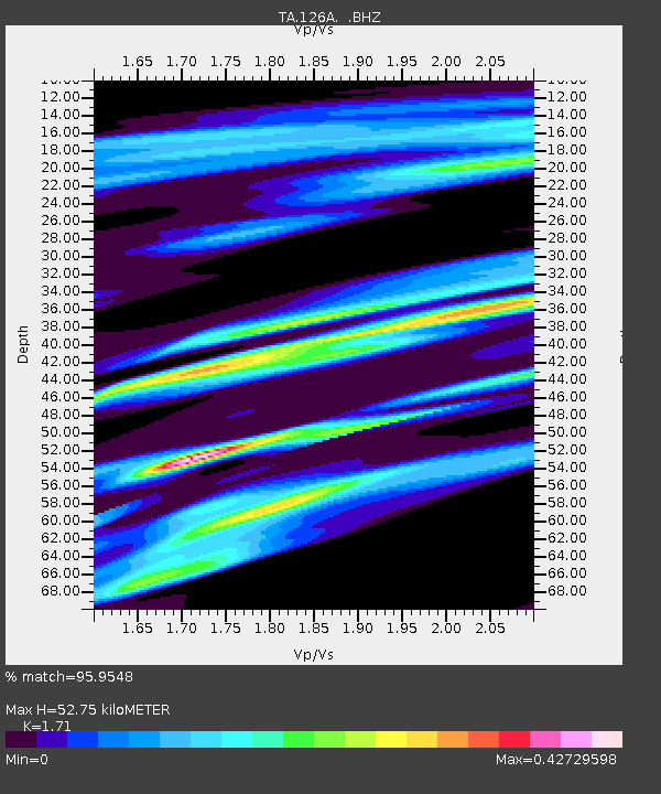
| Estimated Moho Depth: |
52.75 km |
| Estimated Crust Vp/Vs: |
1.71 |
| Assumed Crust Vp: |
6.232 km/s |
| Estimated Crust Vs: |
3.644 km/s |
| Estimated Crust Poisson's Ratio: |
0.24 |
|
| Radial Match: |
95.9548 % |
| Radial Bump: |
331 |
| Transverse Match: |
57.586906 % |
| Transverse Bump: |
317 |
| SOD ConfigId: |
2504 |
| Insert Time: |
2010-03-06 23:29:04.294 +0000 |
| GWidth: |
2.5 |
| Max Bumps: |
400 |
| Tol: |
0.001 |
|

Signal To Noise
| Channel | StoN | STA | LTA |
| TA:126A: :BHZ:20080409T12:59:14.975005Z | 4.760379 | 1.042034E-6 | 2.1889728E-7 |
| TA:126A: :BHN:20080409T12:59:14.975005Z | 0.7407194 | 2.5455608E-7 | 3.4366062E-7 |
| TA:126A: :BHE:20080409T12:59:14.975005Z | 1.8234137 | 2.1370845E-7 | 1.1720238E-7 |
| Arrivals |
| Ps | 6.1 SECOND |
| PpPs | 23 SECOND |
| PsPs/PpSs | 29 SECOND |


