You are here: Home > Network List > UU - University of Utah Regional Network Stations List
> Station KNB Kanab, UT, USA > Earthquake Result Viewer
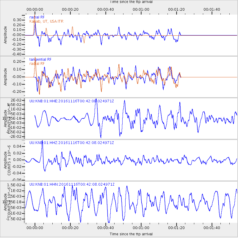
KNB Kanab, UT, USA - Earthquake Result Viewer
*The percent match for this event was below the threshold and hence no stack was calculated.
| Earthquake location: |
Tonga Islands Region |
| Earthquake latitude/longitude: |
-20.2/-173.0 |
| Earthquake time(UTC): |
2016/11/16 (321) 00:30:28 GMT |
| Earthquake Depth: |
10 km |
| Earthquake Magnitude: |
5.9 MB, 5.6 MWB |
| Earthquake Catalog/Contributor: |
NEIC PDE/NEIC COMCAT |
|
| Network: |
UU University of Utah Regional Network |
| Station: |
KNB Kanab, UT, USA |
| Lat/Lon: |
37.02 N/112.82 W |
| Elevation: |
1715 m |
|
| Distance: |
80.3 deg |
| Az: |
44.767 deg |
| Baz: |
235.731 deg |
| Ray Param: |
$rayparam |
*The percent match for this event was below the threshold and hence was not used in the summary stack. |
|
| Radial Match: |
63.6583 % |
| Radial Bump: |
329 |
| Transverse Match: |
47.58726 % |
| Transverse Bump: |
341 |
| SOD ConfigId: |
1858631 |
| Insert Time: |
2016-11-30 00:35:17.111 +0000 |
| GWidth: |
2.5 |
| Max Bumps: |
400 |
| Tol: |
0.001 |
|
Signal To Noise
| Channel | StoN | STA | LTA |
| UU:KNB:01:HHZ:20161116T00:42:08.024971Z | 3.9968877 | 1.9376042E-8 | 4.8477826E-9 |
| UU:KNB:01:HHN:20161116T00:42:08.024971Z | 1.7851408 | 6.804724E-9 | 3.8118695E-9 |
| UU:KNB:01:HHE:20161116T00:42:08.024971Z | 2.2889307 | 8.8786365E-9 | 3.8789447E-9 |
| Arrivals |
| Ps | |
| PpPs | |
| PsPs/PpSs | |


