You are here: Home > Network List > TA - USArray Transportable Network (new EarthScope stations) Stations List
> Station 126A Clayton Basin, Artesia, NM, USA > Earthquake Result Viewer
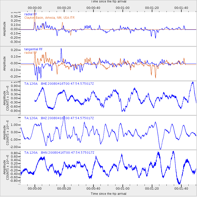
126A Clayton Basin, Artesia, NM, USA - Earthquake Result Viewer
*The percent match for this event was below the threshold and hence no stack was calculated.
| Earthquake location: |
Tonga Islands |
| Earthquake latitude/longitude: |
-18.6/-175.7 |
| Earthquake time(UTC): |
2008/04/16 (107) 00:35:48 GMT |
| Earthquake Depth: |
10 km |
| Earthquake Magnitude: |
5.6 MB, 6.3 MS, 6.3 MW, 6.3 MW |
| Earthquake Catalog/Contributor: |
WHDF/NEIC |
|
| Network: |
TA USArray Transportable Network (new EarthScope stations) |
| Station: |
126A Clayton Basin, Artesia, NM, USA |
| Lat/Lon: |
32.65 N/104.02 W |
| Elevation: |
1032 m |
|
| Distance: |
85.3 deg |
| Az: |
53.47 deg |
| Baz: |
244.592 deg |
| Ray Param: |
$rayparam |
*The percent match for this event was below the threshold and hence was not used in the summary stack. |
|
| Radial Match: |
58.60023 % |
| Radial Bump: |
400 |
| Transverse Match: |
61.55628 % |
| Transverse Bump: |
361 |
| SOD ConfigId: |
2504 |
| Insert Time: |
2010-03-06 23:29:17.714 +0000 |
| GWidth: |
2.5 |
| Max Bumps: |
400 |
| Tol: |
0.001 |
|
Signal To Noise
| Channel | StoN | STA | LTA |
| TA:126A: :BHZ:20080416T00:47:54.575017Z | 2.948318 | 1.0933976E-6 | 3.708547E-7 |
| TA:126A: :BHN:20080416T00:47:54.575017Z | 1.4780306 | 3.642791E-7 | 2.464625E-7 |
| TA:126A: :BHE:20080416T00:47:54.575017Z | 0.6863038 | 3.1173155E-7 | 4.5421802E-7 |
| Arrivals |
| Ps | |
| PpPs | |
| PsPs/PpSs | |


