You are here: Home > Network List > TA - USArray Transportable Network (new EarthScope stations) Stations List
> Station 126A Clayton Basin, Artesia, NM, USA > Earthquake Result Viewer
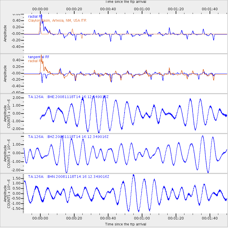
126A Clayton Basin, Artesia, NM, USA - Earthquake Result Viewer
*The percent match for this event was below the threshold and hence no stack was calculated.
| Earthquake location: |
Vanuatu Islands |
| Earthquake latitude/longitude: |
-18.9/169.5 |
| Earthquake time(UTC): |
2008/11/18 (323) 14:03:15 GMT |
| Earthquake Depth: |
35 km |
| Earthquake Magnitude: |
5.5 MB, 5.3 MS, 5.5 MW |
| Earthquake Catalog/Contributor: |
WHDF/NEIC |
|
| Network: |
TA USArray Transportable Network (new EarthScope stations) |
| Station: |
126A Clayton Basin, Artesia, NM, USA |
| Lat/Lon: |
32.65 N/104.02 W |
| Elevation: |
1032 m |
|
| Distance: |
97.1 deg |
| Az: |
58.064 deg |
| Baz: |
252.243 deg |
| Ray Param: |
$rayparam |
*The percent match for this event was below the threshold and hence was not used in the summary stack. |
|
| Radial Match: |
70.68975 % |
| Radial Bump: |
375 |
| Transverse Match: |
57.430744 % |
| Transverse Bump: |
206 |
| SOD ConfigId: |
2658 |
| Insert Time: |
2010-03-06 23:29:39.802 +0000 |
| GWidth: |
2.5 |
| Max Bumps: |
400 |
| Tol: |
0.001 |
|
Signal To Noise
| Channel | StoN | STA | LTA |
| TA:126A: :BHZ:20081118T14:16:12.349016Z | 0.22151263 | 3.4399778E-7 | 1.5529488E-6 |
| TA:126A: :BHN:20081118T14:16:12.349016Z | 0.4248369 | 4.6564884E-7 | 1.096065E-6 |
| TA:126A: :BHE:20081118T14:16:12.349016Z | 2.0529747 | 1.6206461E-6 | 7.894136E-7 |
| Arrivals |
| Ps | |
| PpPs | |
| PsPs/PpSs | |


