You are here: Home > Network List > TA - USArray Transportable Network (new EarthScope stations) Stations List
> Station 126A Clayton Basin, Artesia, NM, USA > Earthquake Result Viewer
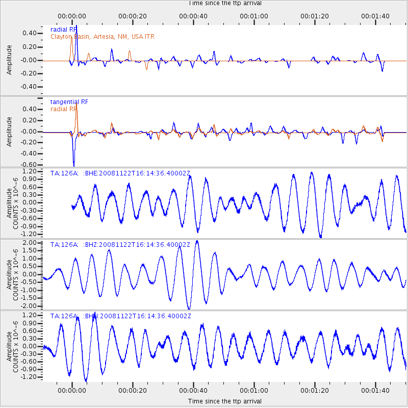
126A Clayton Basin, Artesia, NM, USA - Earthquake Result Viewer
*The percent match for this event was below the threshold and hence no stack was calculated.
| Earthquake location: |
Southeast Of Loyalty Islands |
| Earthquake latitude/longitude: |
-22.5/171.2 |
| Earthquake time(UTC): |
2008/11/22 (327) 16:01:39 GMT |
| Earthquake Depth: |
57 km |
| Earthquake Magnitude: |
5.7 MB, 6.4 MW, 6.4 MW |
| Earthquake Catalog/Contributor: |
WHDF/NEIC |
|
| Network: |
TA USArray Transportable Network (new EarthScope stations) |
| Station: |
126A Clayton Basin, Artesia, NM, USA |
| Lat/Lon: |
32.65 N/104.02 W |
| Elevation: |
1032 m |
|
| Distance: |
97.7 deg |
| Az: |
57.968 deg |
| Baz: |
248.297 deg |
| Ray Param: |
$rayparam |
*The percent match for this event was below the threshold and hence was not used in the summary stack. |
|
| Radial Match: |
84.41694 % |
| Radial Bump: |
264 |
| Transverse Match: |
67.38828 % |
| Transverse Bump: |
352 |
| SOD ConfigId: |
2658 |
| Insert Time: |
2010-03-06 23:29:40.712 +0000 |
| GWidth: |
2.5 |
| Max Bumps: |
400 |
| Tol: |
0.001 |
|
Signal To Noise
| Channel | StoN | STA | LTA |
| TA:126A: :BHZ:20081122T16:14:36.40002Z | 0.7075558 | 7.299295E-7 | 1.0316212E-6 |
| TA:126A: :BHN:20081122T16:14:36.40002Z | 1.9416945 | 8.838375E-7 | 4.5518874E-7 |
| TA:126A: :BHE:20081122T16:14:36.40002Z | 0.83599204 | 3.242223E-7 | 3.8782937E-7 |
| Arrivals |
| Ps | |
| PpPs | |
| PsPs/PpSs | |


