You are here: Home > Network List > TA - USArray Transportable Network (new EarthScope stations) Stations List
> Station 126A Clayton Basin, Artesia, NM, USA > Earthquake Result Viewer
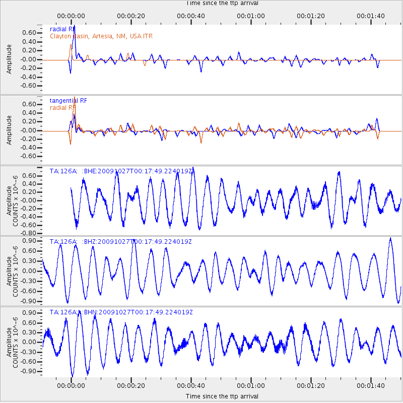
126A Clayton Basin, Artesia, NM, USA - Earthquake Result Viewer
*The percent match for this event was below the threshold and hence no stack was calculated.
| Earthquake location: |
Drake Passage |
| Earthquake latitude/longitude: |
-60.0/-65.2 |
| Earthquake time(UTC): |
2009/10/27 (300) 00:04:46 GMT |
| Earthquake Depth: |
10 km |
| Earthquake Magnitude: |
6.0 MB, 5.8 MS, 6.0 MW, 6.0 MW |
| Earthquake Catalog/Contributor: |
WHDF/NEIC |
|
| Network: |
TA USArray Transportable Network (new EarthScope stations) |
| Station: |
126A Clayton Basin, Artesia, NM, USA |
| Lat/Lon: |
32.65 N/104.02 W |
| Elevation: |
1032 m |
|
| Distance: |
97.7 deg |
| Az: |
327.719 deg |
| Baz: |
161.425 deg |
| Ray Param: |
$rayparam |
*The percent match for this event was below the threshold and hence was not used in the summary stack. |
|
| Radial Match: |
65.51473 % |
| Radial Bump: |
400 |
| Transverse Match: |
48.15032 % |
| Transverse Bump: |
326 |
| SOD ConfigId: |
2622 |
| Insert Time: |
2010-03-06 23:30:12.004 +0000 |
| GWidth: |
2.5 |
| Max Bumps: |
400 |
| Tol: |
0.001 |
|
Signal To Noise
| Channel | StoN | STA | LTA |
| TA:126A: :BHZ:20091027T00:17:49.224019Z | 1.3585829 | 5.556374E-7 | 4.089831E-7 |
| TA:126A: :BHN:20091027T00:17:49.224019Z | 2.9841285 | 6.5772474E-7 | 2.2040766E-7 |
| TA:126A: :BHE:20091027T00:17:49.224019Z | 1.1406318 | 3.7001135E-7 | 3.2439158E-7 |
| Arrivals |
| Ps | |
| PpPs | |
| PsPs/PpSs | |


