You are here: Home > Network List > TA - USArray Transportable Network (new EarthScope stations) Stations List
> Station 126A Clayton Basin, Artesia, NM, USA > Earthquake Result Viewer
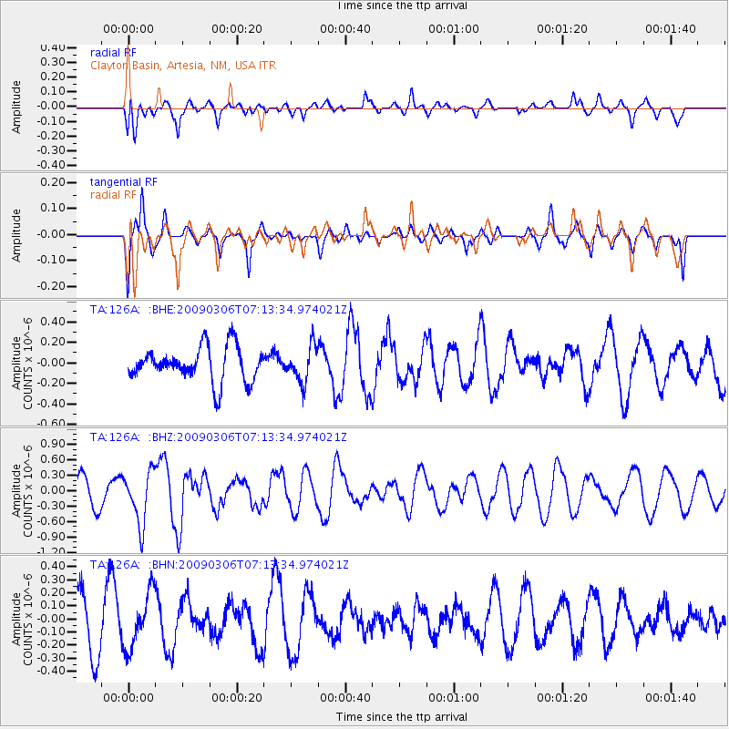
126A Clayton Basin, Artesia, NM, USA - Earthquake Result Viewer
*The percent match for this event was below the threshold and hence no stack was calculated.
| Earthquake location: |
Tonga Islands |
| Earthquake latitude/longitude: |
-15.2/-173.3 |
| Earthquake time(UTC): |
2009/03/06 (065) 07:01:48 GMT |
| Earthquake Depth: |
3.0 km |
| Earthquake Magnitude: |
5.5 MB, 5.4 MS, 5.8 MW, 5.8 MW |
| Earthquake Catalog/Contributor: |
WHDF/NEIC |
|
| Network: |
TA USArray Transportable Network (new EarthScope stations) |
| Station: |
126A Clayton Basin, Artesia, NM, USA |
| Lat/Lon: |
32.65 N/104.02 W |
| Elevation: |
1032 m |
|
| Distance: |
81.5 deg |
| Az: |
52.939 deg |
| Baz: |
245.979 deg |
| Ray Param: |
$rayparam |
*The percent match for this event was below the threshold and hence was not used in the summary stack. |
|
| Radial Match: |
45.126762 % |
| Radial Bump: |
400 |
| Transverse Match: |
48.05037 % |
| Transverse Bump: |
302 |
| SOD ConfigId: |
2658 |
| Insert Time: |
2010-03-06 23:30:20.554 +0000 |
| GWidth: |
2.5 |
| Max Bumps: |
400 |
| Tol: |
0.001 |
|
Signal To Noise
| Channel | StoN | STA | LTA |
| TA:126A: :BHZ:20090306T07:13:34.974021Z | 2.1608622 | 5.171542E-7 | 2.393277E-7 |
| TA:126A: :BHN:20090306T07:13:34.974021Z | 1.0997984 | 2.1454315E-7 | 1.9507496E-7 |
| TA:126A: :BHE:20090306T07:13:34.974021Z | 1.0617682 | 1.7674289E-7 | 1.6646091E-7 |
| Arrivals |
| Ps | |
| PpPs | |
| PsPs/PpSs | |


