You are here: Home > Network List > CN - Canadian National Seismograph Network Stations List
> Station INK INUVIK, NT > Earthquake Result Viewer
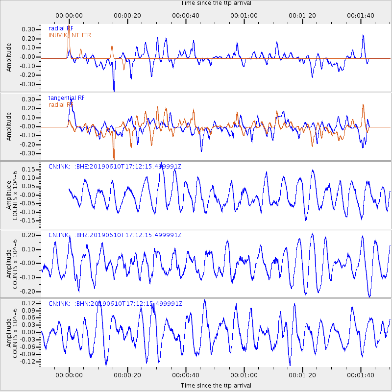
INK INUVIK, NT - Earthquake Result Viewer
*The percent match for this event was below the threshold and hence no stack was calculated.
| Earthquake location: |
Tanimbar Islands Reg., Indonesia |
| Earthquake latitude/longitude: |
-6.6/131.9 |
| Earthquake time(UTC): |
2019/06/10 (161) 16:59:17 GMT |
| Earthquake Depth: |
56 km |
| Earthquake Magnitude: |
5.5 Mww |
| Earthquake Catalog/Contributor: |
NEIC PDE/us |
|
| Network: |
CN Canadian National Seismograph Network |
| Station: |
INK INUVIK, NT |
| Lat/Lon: |
68.31 N/133.53 W |
| Elevation: |
44 m |
|
| Distance: |
97.8 deg |
| Az: |
21.963 deg |
| Baz: |
271.83 deg |
| Ray Param: |
$rayparam |
*The percent match for this event was below the threshold and hence was not used in the summary stack. |
|
| Radial Match: |
54.709778 % |
| Radial Bump: |
400 |
| Transverse Match: |
49.82104 % |
| Transverse Bump: |
400 |
| SOD ConfigId: |
18369291 |
| Insert Time: |
2019-06-24 17:00:15.146 +0000 |
| GWidth: |
2.5 |
| Max Bumps: |
400 |
| Tol: |
0.001 |
|
Signal To Noise
| Channel | StoN | STA | LTA |
| CN:INK: :BHZ:20190610T17:12:15.499991Z | 1.8111565 | 1.0774503E-7 | 5.948963E-8 |
| CN:INK: :BHN:20190610T17:12:15.499991Z | 0.6169372 | 3.6225686E-8 | 5.871859E-8 |
| CN:INK: :BHE:20190610T17:12:15.499991Z | 2.1205127 | 1.0231215E-7 | 4.824878E-8 |
| Arrivals |
| Ps | |
| PpPs | |
| PsPs/PpSs | |


