You are here: Home > Network List > TA - USArray Transportable Network (new EarthScope stations) Stations List
> Station 126A Clayton Basin, Artesia, NM, USA > Earthquake Result Viewer
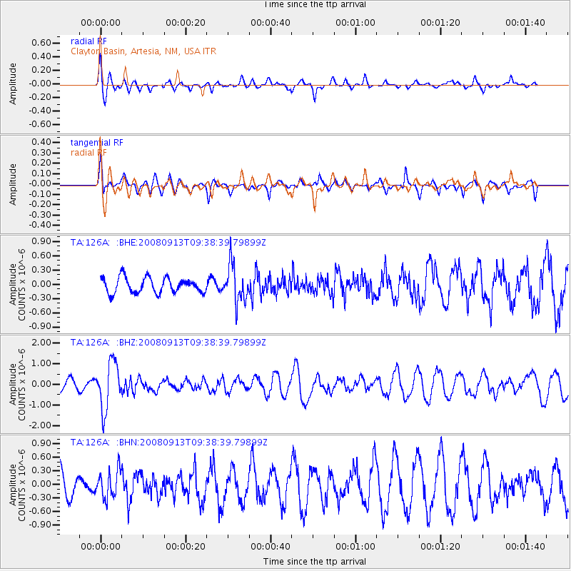
126A Clayton Basin, Artesia, NM, USA - Earthquake Result Viewer
*The percent match for this event was below the threshold and hence no stack was calculated.
| Earthquake location: |
Colombia |
| Earthquake latitude/longitude: |
4.8/-75.5 |
| Earthquake time(UTC): |
2008/09/13 (257) 09:32:01 GMT |
| Earthquake Depth: |
133 km |
| Earthquake Magnitude: |
5.9 MB, 5.7 MW, 5.7 MW |
| Earthquake Catalog/Contributor: |
WHDF/NEIC |
|
| Network: |
TA USArray Transportable Network (new EarthScope stations) |
| Station: |
126A Clayton Basin, Artesia, NM, USA |
| Lat/Lon: |
32.65 N/104.02 W |
| Elevation: |
1032 m |
|
| Distance: |
38.4 deg |
| Az: |
319.629 deg |
| Baz: |
130.081 deg |
| Ray Param: |
$rayparam |
*The percent match for this event was below the threshold and hence was not used in the summary stack. |
|
| Radial Match: |
61.797207 % |
| Radial Bump: |
400 |
| Transverse Match: |
48.68173 % |
| Transverse Bump: |
364 |
| SOD ConfigId: |
2560 |
| Insert Time: |
2010-03-06 23:30:57.092 +0000 |
| GWidth: |
2.5 |
| Max Bumps: |
400 |
| Tol: |
0.001 |
|
Signal To Noise
| Channel | StoN | STA | LTA |
| TA:126A: :BHZ:20080913T09:38:39.79899Z | 4.7103696 | 1.1644662E-6 | 2.4721334E-7 |
| TA:126A: :BHN:20080913T09:38:39.79899Z | 0.9459579 | 3.1048452E-7 | 3.2822234E-7 |
| TA:126A: :BHE:20080913T09:38:39.79899Z | 2.4926476 | 3.9621312E-7 | 1.5895272E-7 |
| Arrivals |
| Ps | |
| PpPs | |
| PsPs/PpSs | |


