You are here: Home > Network List > TA - USArray Transportable Network (new EarthScope stations) Stations List
> Station 427A Hayter Ranch, Fort Stockton, TX, USA > Earthquake Result Viewer
427A Hayter Ranch, Fort Stockton, TX, USA - Earthquake Result Viewer
| Earthquake location: |
Andreanof Islands, Aleutian Is. |
| Earthquake latitude/longitude: |
52.2/-175.7 |
| Earthquake time(UTC): |
2008/08/07 (220) 18:30:03 GMT |
| Earthquake Depth: |
12 km |
| Earthquake Magnitude: |
5.6 MB, 5.5 MS, 5.8 MW, 5.8 MW |
| Earthquake Catalog/Contributor: |
WHDF/NEIC |
|
| Network: |
TA USArray Transportable Network (new EarthScope stations) |
| Station: |
427A Hayter Ranch, Fort Stockton, TX, USA |
| Lat/Lon: |
30.85 N/103.40 W |
| Elevation: |
1031 m |
|
| Distance: |
55.7 deg |
| Az: |
82.524 deg |
| Baz: |
314.788 deg |
| Ray Param: |
0.0646175 |
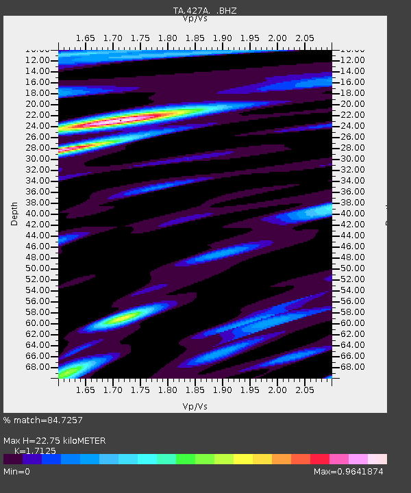
| Estimated Moho Depth: |
22.75 km |
| Estimated Crust Vp/Vs: |
1.71 |
| Assumed Crust Vp: |
6.121 km/s |
| Estimated Crust Vs: |
3.574 km/s |
| Estimated Crust Poisson's Ratio: |
0.24 |
|
| Radial Match: |
84.7257 % |
| Radial Bump: |
400 |
| Transverse Match: |
78.33725 % |
| Transverse Bump: |
400 |
| SOD ConfigId: |
2504 |
| Insert Time: |
2010-03-06 23:31:12.310 +0000 |
| GWidth: |
2.5 |
| Max Bumps: |
400 |
| Tol: |
0.001 |
|

Signal To Noise
| Channel | StoN | STA | LTA |
| TA:427A: :BHZ:20080807T18:39:08.174004Z | 6.617812 | 4.1521594E-7 | 6.2742174E-8 |
| TA:427A: :BHN:20080807T18:39:08.174004Z | 2.905056 | 1.5065059E-7 | 5.1858066E-8 |
| TA:427A: :BHE:20080807T18:39:08.174004Z | 2.7331138 | 1.7551243E-7 | 6.421702E-8 |
| Arrivals |
| Ps | 2.8 SECOND |
| PpPs | 9.6 SECOND |
| PsPs/PpSs | 12 SECOND |


