You are here: Home > Network List > TA - USArray Transportable Network (new EarthScope stations) Stations List
> Station 427A Hayter Ranch, Fort Stockton, TX, USA > Earthquake Result Viewer
427A Hayter Ranch, Fort Stockton, TX, USA - Earthquake Result Viewer
| Earthquake location: |
Central Mid-Atlantic Ridge |
| Earthquake latitude/longitude: |
8.1/-38.7 |
| Earthquake time(UTC): |
2008/09/10 (254) 13:08:14 GMT |
| Earthquake Depth: |
10 km |
| Earthquake Magnitude: |
6.3 MB, 6.5 MS, 6.6 MW, 6.6 MW |
| Earthquake Catalog/Contributor: |
WHDF/NEIC |
|
| Network: |
TA USArray Transportable Network (new EarthScope stations) |
| Station: |
427A Hayter Ranch, Fort Stockton, TX, USA |
| Lat/Lon: |
30.85 N/103.40 W |
| Elevation: |
1031 m |
|
| Distance: |
64.2 deg |
| Az: |
300.274 deg |
| Baz: |
96.108 deg |
| Ray Param: |
0.059086893 |
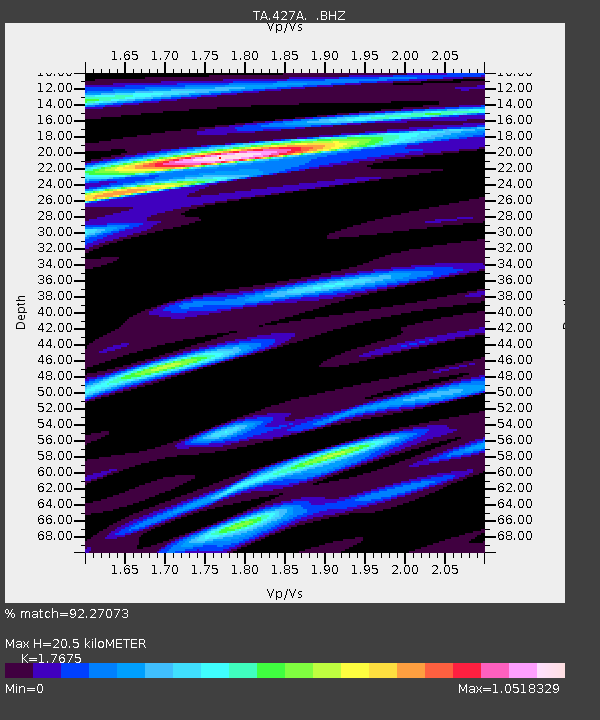
| Estimated Moho Depth: |
20.5 km |
| Estimated Crust Vp/Vs: |
1.77 |
| Assumed Crust Vp: |
6.121 km/s |
| Estimated Crust Vs: |
3.463 km/s |
| Estimated Crust Poisson's Ratio: |
0.26 |
|
| Radial Match: |
92.27073 % |
| Radial Bump: |
400 |
| Transverse Match: |
90.228294 % |
| Transverse Bump: |
400 |
| SOD ConfigId: |
2560 |
| Insert Time: |
2010-03-06 23:31:21.076 +0000 |
| GWidth: |
2.5 |
| Max Bumps: |
400 |
| Tol: |
0.001 |
|

Signal To Noise
| Channel | StoN | STA | LTA |
| TA:427A: :BHZ:20080910T13:18:18.475002Z | 4.008038 | 5.6954275E-7 | 1.4210012E-7 |
| TA:427A: :BHN:20080910T13:18:18.475002Z | 1.124216 | 9.1789445E-8 | 8.164753E-8 |
| TA:427A: :BHE:20080910T13:18:18.475002Z | 1.9840739 | 2.0249742E-7 | 1.02061435E-7 |
| Arrivals |
| Ps | 2.7 SECOND |
| PpPs | 8.9 SECOND |
| PsPs/PpSs | 12 SECOND |


