You are here: Home > Network List > TA - USArray Transportable Network (new EarthScope stations) Stations List
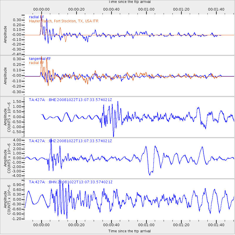
> Station 427A Hayter Ranch, Fort Stockton, TX, USA > Earthquake Result Viewer
427A Hayter Ranch, Fort Stockton, TX, USA - Earthquake Result Viewer
| Earthquake location: |
Tonga Islands |
| Earthquake latitude/longitude: |
-18.4/-175.4 |
| Earthquake time(UTC): |
2008/10/22 (296) 12:55:57 GMT |
| Earthquake Depth: |
233 km |
| Earthquake Magnitude: |
5.9 MB, 6.4 MW, 6.3 MW |
| Earthquake Catalog/Contributor: |
WHDF/NEIC |
|
| Network: |
TA USArray Transportable Network (new EarthScope stations) |
| Station: |
427A Hayter Ranch, Fort Stockton, TX, USA |
| Lat/Lon: |
30.85 N/103.40 W |
| Elevation: |
1031 m |
|
| Distance: |
84.7 deg |
| Az: |
55.209 deg |
| Baz: |
245.042 deg |
| Ray Param: |
0.044740207 |
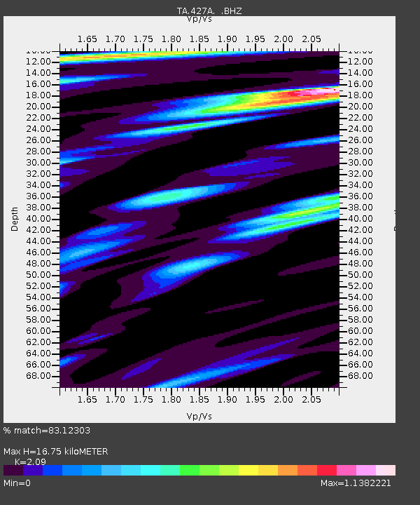
| Estimated Moho Depth: |
16.75 km |
| Estimated Crust Vp/Vs: |
2.09 |
| Assumed Crust Vp: |
6.121 km/s |
| Estimated Crust Vs: |
2.928 km/s |
| Estimated Crust Poisson's Ratio: |
0.35 |
|
| Radial Match: |
83.12303 % |
| Radial Bump: |
400 |
| Transverse Match: |
51.506134 % |
| Transverse Bump: |
393 |
| SOD ConfigId: |
2560 |
| Insert Time: |
2010-03-06 23:31:27.374 +0000 |
| GWidth: |
2.5 |
| Max Bumps: |
400 |
| Tol: |
0.001 |
|
Signal To Noise
| Channel | StoN | STA | LTA |
| TA:427A: :BHZ:20081022T13:07:33.574021Z | 2.4344025 | 6.916993E-7 | 2.8413515E-7 |
| TA:427A: :BHN:20081022T13:07:33.574021Z | 0.8673662 | 2.8813056E-7 | 3.321902E-7 |
| TA:427A: :BHE:20081022T13:07:33.574021Z | 1.3667337 | 2.7708128E-7 | 2.0273247E-7 |
| Arrivals |
| Ps | 3.0 SECOND |
| PpPs | 8.3 SECOND |
| PsPs/PpSs | 11 SECOND |


