You are here: Home > Network List > TA - USArray Transportable Network (new EarthScope stations) Stations List
> Station 427A Hayter Ranch, Fort Stockton, TX, USA > Earthquake Result Viewer
427A Hayter Ranch, Fort Stockton, TX, USA - Earthquake Result Viewer
| Earthquake location: |
Santa Cruz Islands Region |
| Earthquake latitude/longitude: |
-11.0/164.5 |
| Earthquake time(UTC): |
2008/07/19 (201) 09:27:01 GMT |
| Earthquake Depth: |
11 km |
| Earthquake Magnitude: |
6.1 MB, 6.4 MS, 6.6 MW, 6.6 MW |
| Earthquake Catalog/Contributor: |
WHDF/NEIC |
|
| Network: |
TA USArray Transportable Network (new EarthScope stations) |
| Station: |
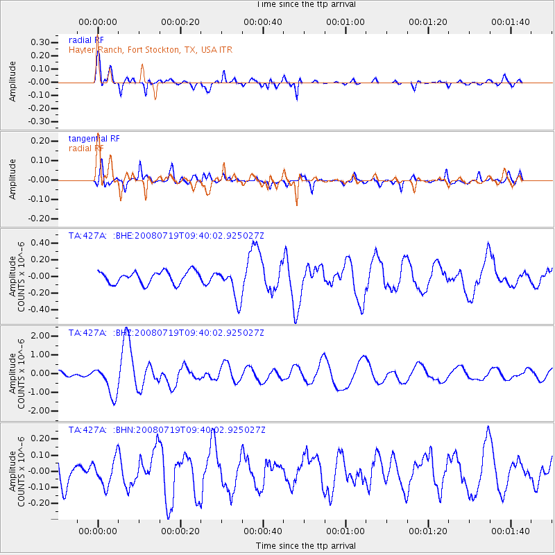
427A Hayter Ranch, Fort Stockton, TX, USA |
| Lat/Lon: |
30.85 N/103.40 W |
| Elevation: |
1031 m |
|
| Distance: |
97.4 deg |
| Az: |
60.064 deg |
| Baz: |
261.579 deg |
| Ray Param: |
0.0402371 |
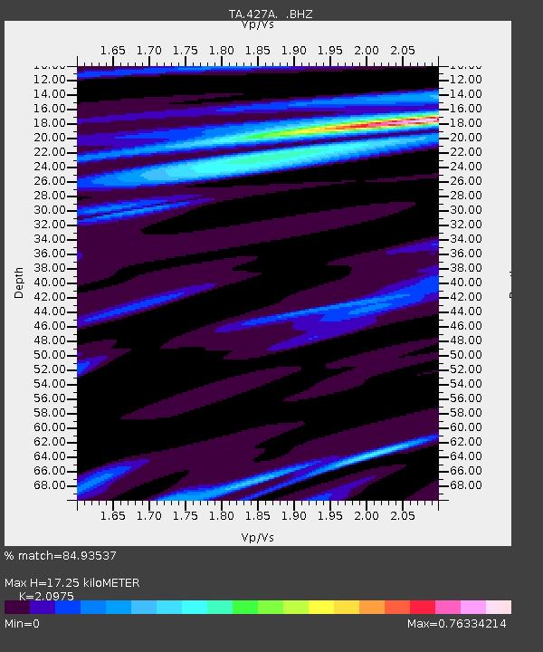
| Estimated Moho Depth: |
17.25 km |
| Estimated Crust Vp/Vs: |
2.10 |
| Assumed Crust Vp: |
6.121 km/s |
| Estimated Crust Vs: |
2.918 km/s |
| Estimated Crust Poisson's Ratio: |
0.35 |
|
| Radial Match: |
84.93537 % |
| Radial Bump: |
400 |
| Transverse Match: |
74.89448 % |
| Transverse Bump: |
400 |
| SOD ConfigId: |
2658 |
| Insert Time: |
2010-03-06 23:31:28.534 +0000 |
| GWidth: |
2.5 |
| Max Bumps: |
400 |
| Tol: |
0.001 |
|
Signal To Noise
| Channel | StoN | STA | LTA |
| TA:427A: :BHZ:20080719T09:40:02.925027Z | 5.260299 | 8.24173E-7 | 1.5667797E-7 |
| TA:427A: :BHN:20080719T09:40:02.925027Z | 0.84728074 | 8.49927E-8 | 1.0031233E-7 |
| TA:427A: :BHE:20080719T09:40:02.925027Z | 2.7685275 | 2.0153524E-7 | 7.2795096E-8 |
| Arrivals |
| Ps | 3.1 SECOND |
| PpPs | 8.6 SECOND |
| PsPs/PpSs | 12 SECOND |


