You are here: Home > Network List > AV - Alaska Volcano Observatory Stations List
> Station MAPS Pakushin Southeast, Makushin Volcano, Alaska > Earthquake Result Viewer
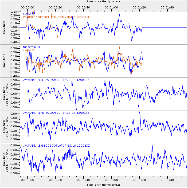
MAPS Pakushin Southeast, Makushin Volcano, Alaska - Earthquake Result Viewer
*The percent match for this event was below the threshold and hence no stack was calculated.
| Earthquake location: |
Mariana Islands Region |
| Earthquake latitude/longitude: |
17.4/147.8 |
| Earthquake time(UTC): |
2019/06/10 (161) 17:14:53 GMT |
| Earthquake Depth: |
22 km |
| Earthquake Magnitude: |
5.4 Mww |
| Earthquake Catalog/Contributor: |
NEIC PDE/us |
|
| Network: |
AV Alaska Volcano Observatory |
| Station: |
MAPS Pakushin Southeast, Makushin Volcano, Alaska |
| Lat/Lon: |
53.81 N/166.94 W |
| Elevation: |
333 m |
|
| Distance: |
50.4 deg |
| Az: |
33.174 deg |
| Baz: |
241.755 deg |
| Ray Param: |
$rayparam |
*The percent match for this event was below the threshold and hence was not used in the summary stack. |
|
| Radial Match: |
58.65231 % |
| Radial Bump: |
311 |
| Transverse Match: |
54.01076 % |
| Transverse Bump: |
400 |
| SOD ConfigId: |
18369291 |
| Insert Time: |
2019-06-24 17:16:18.503 +0000 |
| GWidth: |
2.5 |
| Max Bumps: |
400 |
| Tol: |
0.001 |
|
Signal To Noise
| Channel | StoN | STA | LTA |
| AV:MAPS: :BHZ:20190610T17:23:18.120013Z | 2.3541982 | 4.840402E-7 | 2.0560724E-7 |
| AV:MAPS: :BHN:20190610T17:23:18.120013Z | 1.1897582 | 3.9087166E-7 | 3.2853035E-7 |
| AV:MAPS: :BHE:20190610T17:23:18.120013Z | 1.76282 | 4.4992342E-7 | 2.5522934E-7 |
| Arrivals |
| Ps | |
| PpPs | |
| PsPs/PpSs | |


