You are here: Home > Network List > TA - USArray Transportable Network (new EarthScope stations) Stations List
> Station 427A Hayter Ranch, Fort Stockton, TX, USA > Earthquake Result Viewer
427A Hayter Ranch, Fort Stockton, TX, USA - Earthquake Result Viewer
| Earthquake location: |
Tonga Islands |
| Earthquake latitude/longitude: |
-20.8/-174.3 |
| Earthquake time(UTC): |
2009/07/30 (211) 20:05:34 GMT |
| Earthquake Depth: |
10 km |
| Earthquake Magnitude: |
5.9 MB, 5.7 MS, 5.8 MW, 5.7 MW |
| Earthquake Catalog/Contributor: |
WHDF/NEIC |
|
| Network: |
TA USArray Transportable Network (new EarthScope stations) |
| Station: |
427A Hayter Ranch, Fort Stockton, TX, USA |
| Lat/Lon: |
30.85 N/103.40 W |
| Elevation: |
1031 m |
|
| Distance: |
85.2 deg |
| Az: |
54.615 deg |
| Baz: |
242.455 deg |
| Ray Param: |
0.044920936 |
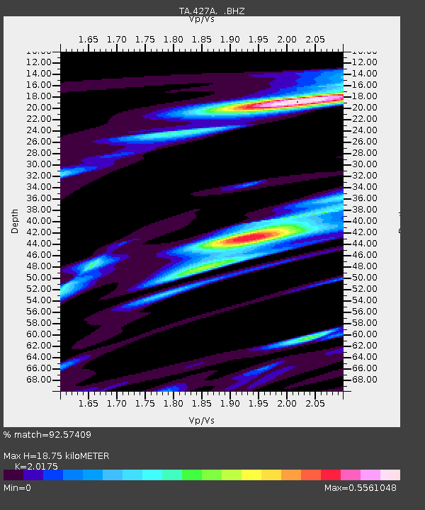
| Estimated Moho Depth: |
18.75 km |
| Estimated Crust Vp/Vs: |
2.02 |
| Assumed Crust Vp: |
6.121 km/s |
| Estimated Crust Vs: |
3.034 km/s |
| Estimated Crust Poisson's Ratio: |
0.34 |
|
| Radial Match: |
92.57409 % |
| Radial Bump: |
400 |
| Transverse Match: |
84.41504 % |
| Transverse Bump: |
400 |
| SOD ConfigId: |
2622 |
| Insert Time: |
2010-03-06 23:31:33.961 +0000 |
| GWidth: |
2.5 |
| Max Bumps: |
400 |
| Tol: |
0.001 |
|

Signal To Noise
| Channel | StoN | STA | LTA |
| TA:427A: :BHZ:20090730T20:17:40.075022Z | 5.5518217 | 4.994572E-7 | 8.996276E-8 |
| TA:427A: :BHN:20090730T20:17:40.075022Z | 1.3749708 | 6.7699766E-8 | 4.9237237E-8 |
| TA:427A: :BHE:20090730T20:17:40.075022Z | 2.0888975 | 1.3882922E-7 | 6.646053E-8 |
| Arrivals |
| Ps | 3.2 SECOND |
| PpPs | 9.1 SECOND |
| PsPs/PpSs | 12 SECOND |


