You are here: Home > Network List > GS - US Geological Survey Networks Stations List
> Station KAN08 Pence Farm, Harper, KS, USA > Earthquake Result Viewer
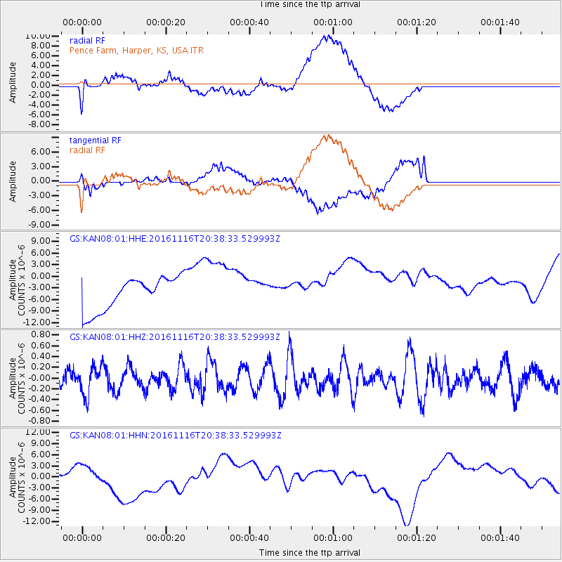
KAN08 Pence Farm, Harper, KS, USA - Earthquake Result Viewer
*The percent match for this event was below the threshold and hence no stack was calculated.
| Earthquake location: |
South Of Fiji Islands |
| Earthquake latitude/longitude: |
-22.1/-177.6 |
| Earthquake time(UTC): |
2016/11/16 (321) 20:26:15 GMT |
| Earthquake Depth: |
305 km |
| Earthquake Magnitude: |
5.5 MB |
| Earthquake Catalog/Contributor: |
NEIC PDE/NEIC COMCAT |
|
| Network: |
GS US Geological Survey Networks |
| Station: |
KAN08 Pence Farm, Harper, KS, USA |
| Lat/Lon: |
37.23 N/97.97 W |
| Elevation: |
375 m |
|
| Distance: |
95.3 deg |
| Az: |
52.055 deg |
| Baz: |
246.357 deg |
| Ray Param: |
$rayparam |
*The percent match for this event was below the threshold and hence was not used in the summary stack. |
|
| Radial Match: |
27.334457 % |
| Radial Bump: |
400 |
| Transverse Match: |
31.111666 % |
| Transverse Bump: |
400 |
| SOD ConfigId: |
1858631 |
| Insert Time: |
2016-11-30 20:27:47.002 +0000 |
| GWidth: |
2.5 |
| Max Bumps: |
400 |
| Tol: |
0.001 |
|
Signal To Noise
| Channel | StoN | STA | LTA |
| GS:KAN08:01:HHZ:20161116T20:38:33.529993Z | 1.296683 | 2.7089456E-7 | 2.0891348E-7 |
| GS:KAN08:01:HHN:20161116T20:38:33.529993Z | 0.6628982 | 1.7030936E-6 | 2.5691634E-6 |
| GS:KAN08:01:HHE:20161116T20:38:33.529993Z | 1.8642608 | 7.977267E-6 | 4.279051E-6 |
| Arrivals |
| Ps | |
| PpPs | |
| PsPs/PpSs | |


