You are here: Home > Network List > TA - USArray Transportable Network (new EarthScope stations) Stations List
> Station 427A Hayter Ranch, Fort Stockton, TX, USA > Earthquake Result Viewer
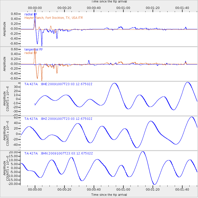
427A Hayter Ranch, Fort Stockton, TX, USA - Earthquake Result Viewer
| Earthquake location: |
Santa Cruz Islands |
| Earthquake latitude/longitude: |
-12.4/166.1 |
| Earthquake time(UTC): |
2009/10/07 (280) 22:50:15 GMT |
| Earthquake Depth: |
21 km |
| Earthquake Magnitude: |
5.8 MB |
| Earthquake Catalog/Contributor: |
WHDF/NEIC |
|
| Network: |
TA USArray Transportable Network (new EarthScope stations) |
| Station: |
427A Hayter Ranch, Fort Stockton, TX, USA |
| Lat/Lon: |
30.85 N/103.40 W |
| Elevation: |
1031 m |
|
| Distance: |
96.7 deg |
| Az: |
59.982 deg |
| Baz: |
259.623 deg |
| Ray Param: |
0.04043605 |
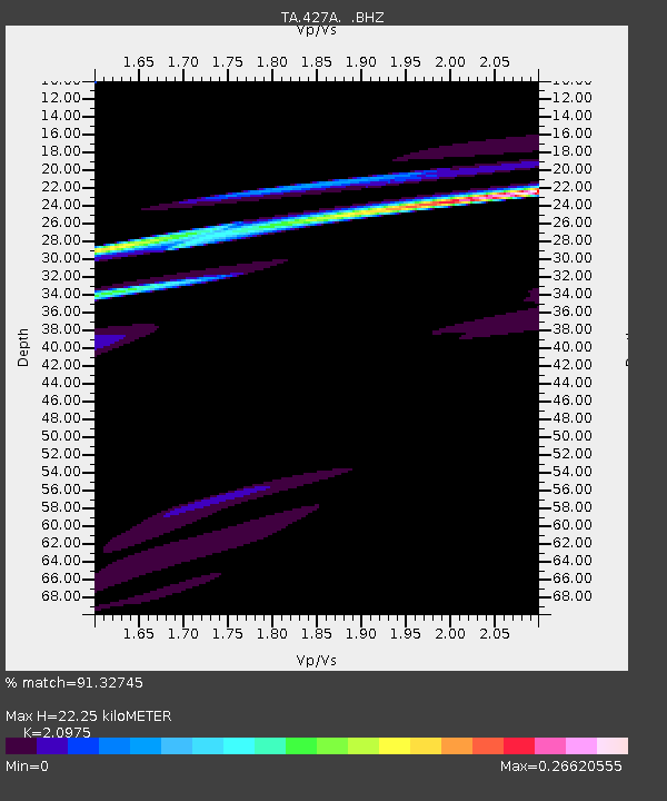
| Estimated Moho Depth: |
22.25 km |
| Estimated Crust Vp/Vs: |
2.10 |
| Assumed Crust Vp: |
6.121 km/s |
| Estimated Crust Vs: |
2.918 km/s |
| Estimated Crust Poisson's Ratio: |
0.35 |
|
| Radial Match: |
91.32745 % |
| Radial Bump: |
400 |
| Transverse Match: |
48.477707 % |
| Transverse Bump: |
248 |
| SOD ConfigId: |
2622 |
| Insert Time: |
2010-03-06 23:31:47.009 +0000 |
| GWidth: |
2.5 |
| Max Bumps: |
400 |
| Tol: |
0.001 |
|
Signal To Noise
| Channel | StoN | STA | LTA |
| TA:427A: :BHZ:20091007T23:03:12.67502Z | 1.1190401 | 1.1757015E-5 | 1.0506339E-5 |
| TA:427A: :BHN:20091007T23:03:12.67502Z | 1.6149534 | 1.0412274E-5 | 6.4474143E-6 |
| TA:427A: :BHE:20091007T23:03:12.67502Z | 3.0832074 | 1.8173556E-5 | 5.894367E-6 |
| Arrivals |
| Ps | 4.0 SECOND |
| PpPs | 11 SECOND |
| PsPs/PpSs | 15 SECOND |


