You are here: Home > Network List > CN - Canadian National Seismograph Network Stations List
> Station INK INUVIK, NT > Earthquake Result Viewer
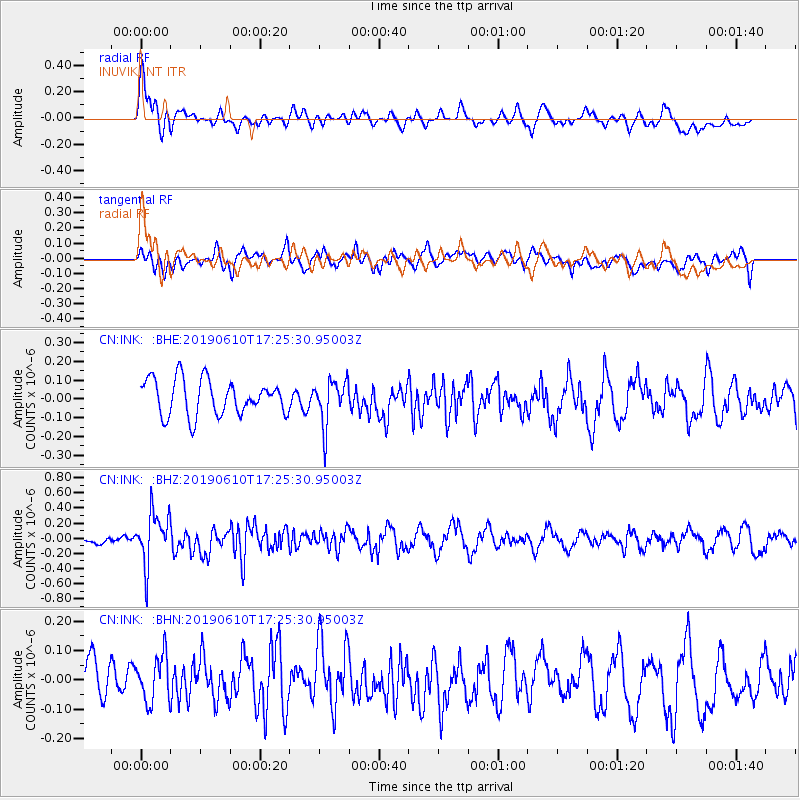
INK INUVIK, NT - Earthquake Result Viewer
*The percent match for this event was below the threshold and hence no stack was calculated.
| Earthquake location: |
Mariana Islands Region |
| Earthquake latitude/longitude: |
17.4/147.8 |
| Earthquake time(UTC): |
2019/06/10 (161) 17:14:53 GMT |
| Earthquake Depth: |
22 km |
| Earthquake Magnitude: |
5.4 Mww |
| Earthquake Catalog/Contributor: |
NEIC PDE/us |
|
| Network: |
CN Canadian National Seismograph Network |
| Station: |
INK INUVIK, NT |
| Lat/Lon: |
68.31 N/133.53 W |
| Elevation: |
44 m |
|
| Distance: |
69.8 deg |
| Az: |
22.862 deg |
| Baz: |
266.146 deg |
| Ray Param: |
$rayparam |
*The percent match for this event was below the threshold and hence was not used in the summary stack. |
|
| Radial Match: |
64.65384 % |
| Radial Bump: |
400 |
| Transverse Match: |
49.517437 % |
| Transverse Bump: |
400 |
| SOD ConfigId: |
18369291 |
| Insert Time: |
2019-06-24 17:17:46.310 +0000 |
| GWidth: |
2.5 |
| Max Bumps: |
400 |
| Tol: |
0.001 |
|
Signal To Noise
| Channel | StoN | STA | LTA |
| CN:INK: :BHZ:20190610T17:25:30.95003Z | 7.3032923 | 3.4216805E-7 | 4.6851206E-8 |
| CN:INK: :BHN:20190610T17:25:30.95003Z | 1.1087618 | 8.3450885E-8 | 7.5264936E-8 |
| CN:INK: :BHE:20190610T17:25:30.95003Z | 1.2632539 | 1.1917969E-7 | 9.434341E-8 |
| Arrivals |
| Ps | |
| PpPs | |
| PsPs/PpSs | |


