You are here: Home > Network List > TA - USArray Transportable Network (new EarthScope stations) Stations List
> Station 427A Hayter Ranch, Fort Stockton, TX, USA > Earthquake Result Viewer
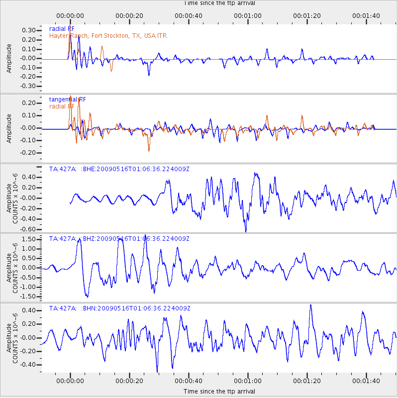
427A Hayter Ranch, Fort Stockton, TX, USA - Earthquake Result Viewer
| Earthquake location: |
Kermadec Islands Region |
| Earthquake latitude/longitude: |
-31.5/-178.8 |
| Earthquake time(UTC): |
2009/05/16 (136) 00:53:52 GMT |
| Earthquake Depth: |
55 km |
| Earthquake Magnitude: |
6.1 MB, 6.5 MW, 6.3 MW |
| Earthquake Catalog/Contributor: |
WHDF/NEIC |
|
| Network: |
TA USArray Transportable Network (new EarthScope stations) |
| Station: |
427A Hayter Ranch, Fort Stockton, TX, USA |
| Lat/Lon: |
30.85 N/103.40 W |
| Elevation: |
1031 m |
|
| Distance: |
94.6 deg |
| Az: |
56.606 deg |
| Baz: |
236.004 deg |
| Ray Param: |
0.040972628 |
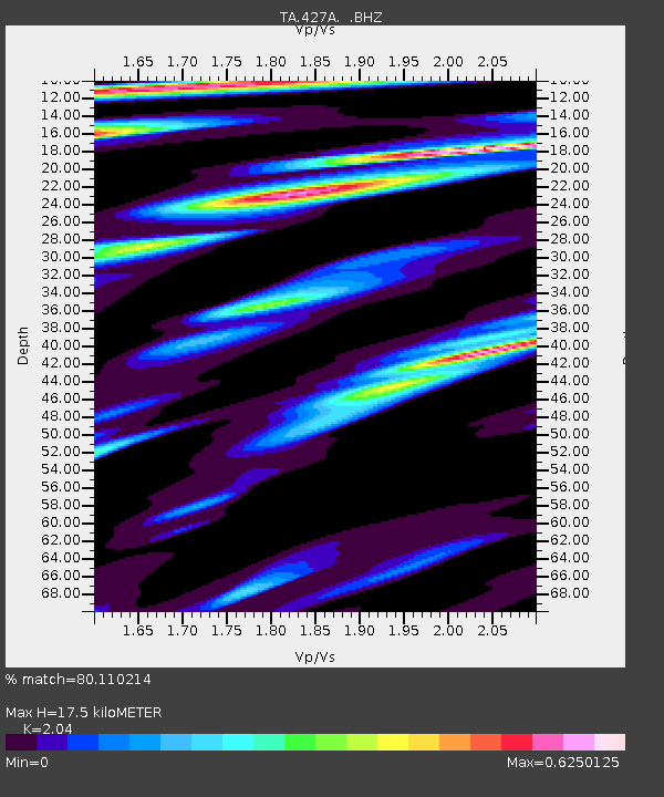
| Estimated Moho Depth: |
17.5 km |
| Estimated Crust Vp/Vs: |
2.04 |
| Assumed Crust Vp: |
6.121 km/s |
| Estimated Crust Vs: |
3.0 km/s |
| Estimated Crust Poisson's Ratio: |
0.34 |
|
| Radial Match: |
80.110214 % |
| Radial Bump: |
400 |
| Transverse Match: |
74.30958 % |
| Transverse Bump: |
400 |
| SOD ConfigId: |
2760 |
| Insert Time: |
2010-03-06 23:32:12.753 +0000 |
| GWidth: |
2.5 |
| Max Bumps: |
400 |
| Tol: |
0.001 |
|
Signal To Noise
| Channel | StoN | STA | LTA |
| TA:427A: :BHZ:20090516T01:06:36.224009Z | 6.245099 | 8.0559965E-7 | 1.289971E-7 |
| TA:427A: :BHN:20090516T01:06:36.224009Z | 1.0019857 | 8.5404345E-8 | 8.52351E-8 |
| TA:427A: :BHE:20090516T01:06:36.224009Z | 3.9209075 | 2.021937E-7 | 5.156809E-8 |
| Arrivals |
| Ps | 3.0 SECOND |
| PpPs | 8.6 SECOND |
| PsPs/PpSs | 12 SECOND |


