You are here: Home > Network List > TA - USArray Transportable Network (new EarthScope stations) Stations List
> Station 427A Hayter Ranch, Fort Stockton, TX, USA > Earthquake Result Viewer
427A Hayter Ranch, Fort Stockton, TX, USA - Earthquake Result Viewer
| Earthquake location: |
Loyalty Islands |
| Earthquake latitude/longitude: |
-20.1/168.9 |
| Earthquake time(UTC): |
2008/04/09 (100) 12:46:12 GMT |
| Earthquake Depth: |
33 km |
| Earthquake Magnitude: |
6.3 MB, 7.3 MS, 7.3 MW, 7.3 MW |
| Earthquake Catalog/Contributor: |
WHDF/NEIC |
|
| Network: |
TA USArray Transportable Network (new EarthScope stations) |
| Station: |
427A Hayter Ranch, Fort Stockton, TX, USA |
| Lat/Lon: |
30.85 N/103.40 W |
| Elevation: |
1031 m |
|
| Distance: |
98.1 deg |
| Az: |
60.238 deg |
| Baz: |
251.592 deg |
| Ray Param: |
0.0399768 |
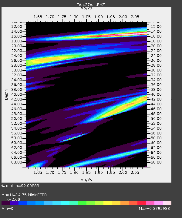
| Estimated Moho Depth: |
14.75 km |
| Estimated Crust Vp/Vs: |
2.06 |
| Assumed Crust Vp: |
6.121 km/s |
| Estimated Crust Vs: |
2.971 km/s |
| Estimated Crust Poisson's Ratio: |
0.35 |
|
| Radial Match: |
92.00888 % |
| Radial Bump: |
211 |
| Transverse Match: |
81.95667 % |
| Transverse Bump: |
265 |
| SOD ConfigId: |
2504 |
| Insert Time: |
2010-03-06 23:32:15.415 +0000 |
| GWidth: |
2.5 |
| Max Bumps: |
400 |
| Tol: |
0.001 |
|
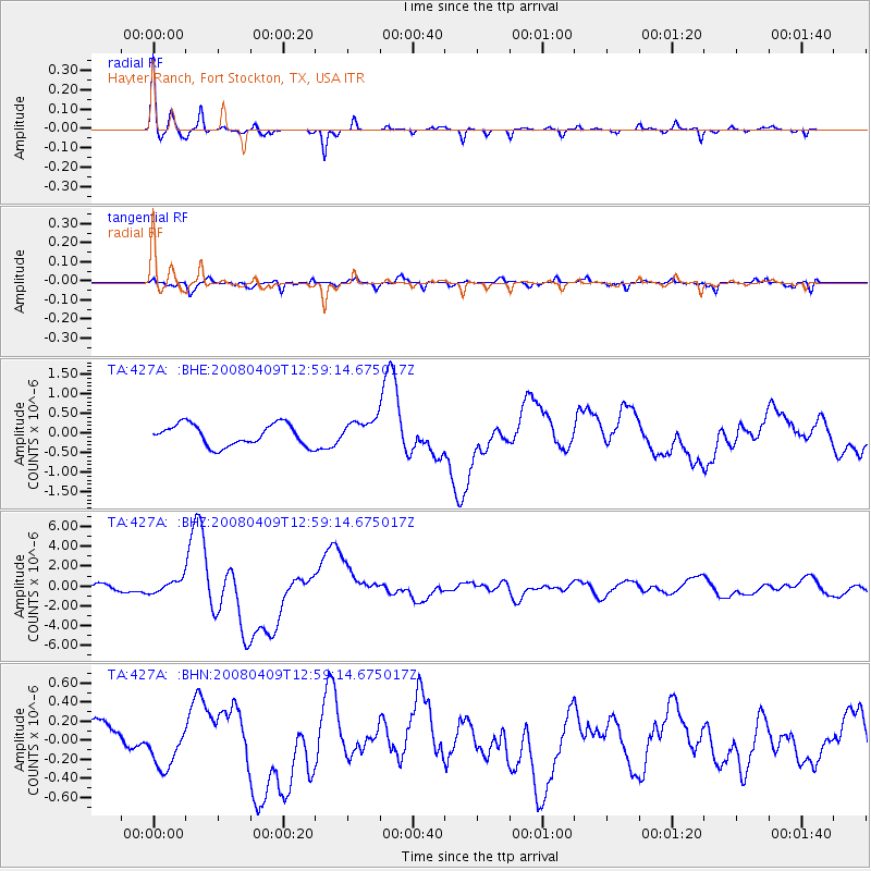
Signal To Noise
| Channel | StoN | STA | LTA |
| TA:427A: :BHZ:20080409T12:59:14.675017Z | 2.6935418 | 6.4642893E-7 | 2.3999218E-7 |
| TA:427A: :BHN:20080409T12:59:14.675017Z | 1.347176 | 2.109325E-7 | 1.5657383E-7 |
| TA:427A: :BHE:20080409T12:59:14.675017Z | 1.1982392 | 3.2547655E-7 | 2.71629E-7 |
| Arrivals |
| Ps | 2.6 SECOND |
| PpPs | 7.3 SECOND |
| PsPs/PpSs | 9.9 SECOND |


