You are here: Home > Network List > US - United States National Seismic Network Stations List
> Station BOZ Bozeman, Montana, USA > Earthquake Result Viewer
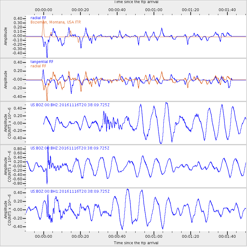
BOZ Bozeman, Montana, USA - Earthquake Result Viewer
*The percent match for this event was below the threshold and hence no stack was calculated.
| Earthquake location: |
South Of Fiji Islands |
| Earthquake latitude/longitude: |
-22.1/-177.6 |
| Earthquake time(UTC): |
2016/11/16 (321) 20:26:15 GMT |
| Earthquake Depth: |
305 km |
| Earthquake Magnitude: |
5.5 MB |
| Earthquake Catalog/Contributor: |
NEIC PDE/NEIC COMCAT |
|
| Network: |
US United States National Seismic Network |
| Station: |
BOZ Bozeman, Montana, USA |
| Lat/Lon: |
45.65 N/111.63 W |
| Elevation: |
1589 m |
|
| Distance: |
90.1 deg |
| Az: |
39.851 deg |
| Baz: |
237.886 deg |
| Ray Param: |
$rayparam |
*The percent match for this event was below the threshold and hence was not used in the summary stack. |
|
| Radial Match: |
68.13164 % |
| Radial Bump: |
400 |
| Transverse Match: |
64.46136 % |
| Transverse Bump: |
400 |
| SOD ConfigId: |
1858631 |
| Insert Time: |
2016-11-30 20:30:54.424 +0000 |
| GWidth: |
2.5 |
| Max Bumps: |
400 |
| Tol: |
0.001 |
|
Signal To Noise
| Channel | StoN | STA | LTA |
| US:BOZ:00:BHZ:20161116T20:38:09.725Z | 2.6598928 | 3.2066202E-7 | 1.205545E-7 |
| US:BOZ:00:BH1:20161116T20:38:09.725Z | 1.4178439 | 1.8452553E-7 | 1.3014517E-7 |
| US:BOZ:00:BH2:20161116T20:38:09.725Z | 1.5710627 | 1.5675398E-7 | 9.977577E-8 |
| Arrivals |
| Ps | |
| PpPs | |
| PsPs/PpSs | |


