You are here: Home > Network List > TS - TERRAscope (Southern California Seismic Network) Stations List
> Station GSC Goldston, California, USA > Earthquake Result Viewer
GSC Goldston, California, USA - Earthquake Result Viewer
| Earthquake location: |
Kuril Islands |
| Earthquake latitude/longitude: |
45.6/151.7 |
| Earthquake time(UTC): |
1991/12/13 (347) 18:59:11 GMT |
| Earthquake Depth: |
52 km |
| Earthquake Magnitude: |
6.2 MB |
| Earthquake Catalog/Contributor: |
WHDF/NEIC |
|
| Network: |
TS TERRAscope (Southern California Seismic Network) |
| Station: |
GSC Goldston, California, USA |
| Lat/Lon: |
35.30 N/116.81 W |
| Elevation: |
990 m |
|
| Distance: |
66.8 deg |
| Az: |
62.857 deg |
| Baz: |
310.144 deg |
| Ray Param: |
0.057291217 |
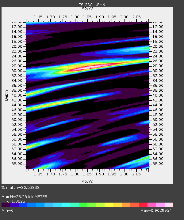
| Estimated Moho Depth: |
28.25 km |
| Estimated Crust Vp/Vs: |
1.86 |
| Assumed Crust Vp: |
6.276 km/s |
| Estimated Crust Vs: |
3.37 km/s |
| Estimated Crust Poisson's Ratio: |
0.30 |
|
| Radial Match: |
80.53838 % |
| Radial Bump: |
400 |
| Transverse Match: |
74.773964 % |
| Transverse Bump: |
400 |
| SOD ConfigId: |
16938 |
| Insert Time: |
2010-02-26 14:15:21.227 +0000 |
| GWidth: |
2.5 |
| Max Bumps: |
400 |
| Tol: |
0.001 |
|

Signal To Noise
| Channel | StoN | STA | LTA |
| TS:GSC: :BHN:19911213T19:09:26.098022Z | 1.2516043 | 2.8268508E-7 | 2.2585819E-7 |
| TS:GSC: :BHE:19911213T19:09:26.098022Z | 1.6690043 | 5.2004094E-7 | 3.1158754E-7 |
| TS:GSC: :BHZ:19911213T19:09:26.098022Z | 2.8718615 | 4.908913E-7 | 1.709314E-7 |
| Arrivals |
| Ps | 4.0 SECOND |
| PpPs | 12 SECOND |
| PsPs/PpSs | 16 SECOND |


