You are here: Home > Network List > TA - USArray Transportable Network (new EarthScope stations) Stations List
> Station J20K Nowitna River, AK, USA > Earthquake Result Viewer
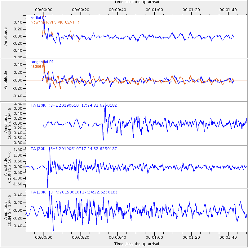
J20K Nowitna River, AK, USA - Earthquake Result Viewer
*The percent match for this event was below the threshold and hence no stack was calculated.
| Earthquake location: |
Mariana Islands Region |
| Earthquake latitude/longitude: |
17.4/147.8 |
| Earthquake time(UTC): |
2019/06/10 (161) 17:14:53 GMT |
| Earthquake Depth: |
22 km |
| Earthquake Magnitude: |
5.4 Mww |
| Earthquake Catalog/Contributor: |
NEIC PDE/us |
|
| Network: |
TA USArray Transportable Network (new EarthScope stations) |
| Station: |
J20K Nowitna River, AK, USA |
| Lat/Lon: |
64.18 N/154.15 W |
| Elevation: |
314 m |
|
| Distance: |
60.8 deg |
| Az: |
25.214 deg |
| Baz: |
248.235 deg |
| Ray Param: |
$rayparam |
*The percent match for this event was below the threshold and hence was not used in the summary stack. |
|
| Radial Match: |
68.47968 % |
| Radial Bump: |
400 |
| Transverse Match: |
77.01355 % |
| Transverse Bump: |
400 |
| SOD ConfigId: |
18369291 |
| Insert Time: |
2019-06-24 17:21:06.198 +0000 |
| GWidth: |
2.5 |
| Max Bumps: |
400 |
| Tol: |
0.001 |
|
Signal To Noise
| Channel | StoN | STA | LTA |
| TA:J20K: :BHZ:20190610T17:24:32.625018Z | 7.6588583 | 7.357646E-7 | 9.606714E-8 |
| TA:J20K: :BHN:20190610T17:24:32.625018Z | 3.0728722 | 1.8904066E-7 | 6.151921E-8 |
| TA:J20K: :BHE:20190610T17:24:32.625018Z | 3.8305256 | 3.1765506E-7 | 8.292728E-8 |
| Arrivals |
| Ps | |
| PpPs | |
| PsPs/PpSs | |


