You are here: Home > Network List > TA - USArray Transportable Network (new EarthScope stations) Stations List
> Station 427A Hayter Ranch, Fort Stockton, TX, USA > Earthquake Result Viewer
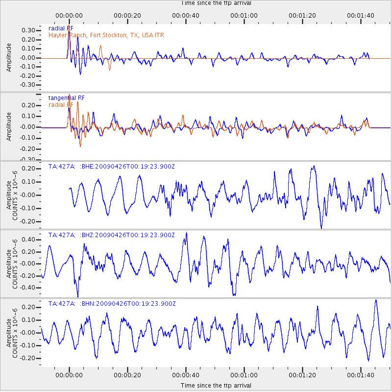
427A Hayter Ranch, Fort Stockton, TX, USA - Earthquake Result Viewer
*The percent match for this event was below the threshold and hence no stack was calculated.
| Earthquake location: |
Kermadec Islands, New Zealand |
| Earthquake latitude/longitude: |
-30.3/-178.6 |
| Earthquake time(UTC): |
2009/04/26 (116) 00:06:53 GMT |
| Earthquake Depth: |
132 km |
| Earthquake Magnitude: |
5.5 MB, 6.1 MW, 6.1 MW |
| Earthquake Catalog/Contributor: |
WHDF/NEIC |
|
| Network: |
TA USArray Transportable Network (new EarthScope stations) |
| Station: |
427A Hayter Ranch, Fort Stockton, TX, USA |
| Lat/Lon: |
30.85 N/103.40 W |
| Elevation: |
1031 m |
|
| Distance: |
93.8 deg |
| Az: |
56.432 deg |
| Baz: |
236.921 deg |
| Ray Param: |
$rayparam |
*The percent match for this event was below the threshold and hence was not used in the summary stack. |
|
| Radial Match: |
66.54993 % |
| Radial Bump: |
400 |
| Transverse Match: |
49.62042 % |
| Transverse Bump: |
355 |
| SOD ConfigId: |
2658 |
| Insert Time: |
2010-03-06 23:33:29.257 +0000 |
| GWidth: |
2.5 |
| Max Bumps: |
400 |
| Tol: |
0.001 |
|
Signal To Noise
| Channel | StoN | STA | LTA |
| TA:427A: :BHZ:20090426T00:19:23.900Z | 1.8186395 | 2.2978115E-7 | 1.2634783E-7 |
| TA:427A: :BHN:20090426T00:19:23.900Z | 1.3126392 | 7.0327864E-8 | 5.357745E-8 |
| TA:427A: :BHE:20090426T00:19:23.900Z | 0.6927281 | 5.9266313E-8 | 8.5554944E-8 |
| Arrivals |
| Ps | |
| PpPs | |
| PsPs/PpSs | |


