You are here: Home > Network List > TA - USArray Transportable Network (new EarthScope stations) Stations List
> Station 427A Hayter Ranch, Fort Stockton, TX, USA > Earthquake Result Viewer
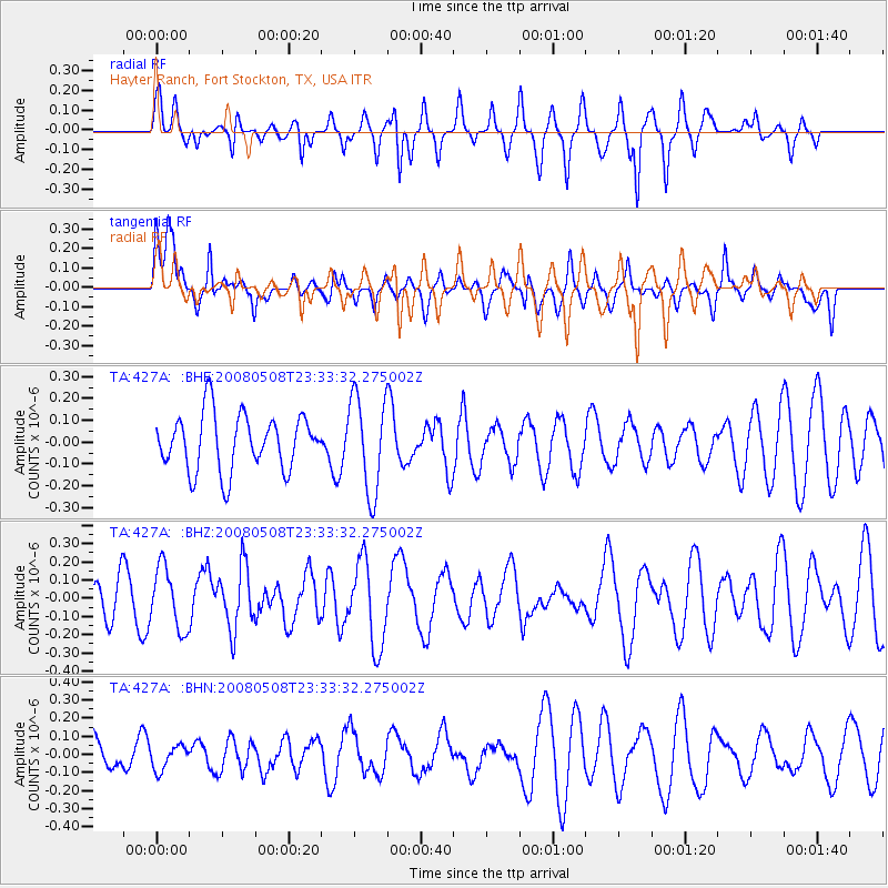
427A Hayter Ranch, Fort Stockton, TX, USA - Earthquake Result Viewer
*The percent match for this event was below the threshold and hence no stack was calculated.
| Earthquake location: |
Near East Coast Of Honshu, Japan |
| Earthquake latitude/longitude: |
36.1/141.7 |
| Earthquake time(UTC): |
2008/05/08 (129) 23:21:06 GMT |
| Earthquake Depth: |
17 km |
| Earthquake Magnitude: |
5.6 MB, 5.2 MS, 5.6 MW, 5.5 MW |
| Earthquake Catalog/Contributor: |
WHDF/NEIC |
|
| Network: |
TA USArray Transportable Network (new EarthScope stations) |
| Station: |
427A Hayter Ranch, Fort Stockton, TX, USA |
| Lat/Lon: |
30.85 N/103.40 W |
| Elevation: |
1031 m |
|
| Distance: |
89.7 deg |
| Az: |
51.26 deg |
| Baz: |
312.741 deg |
| Ray Param: |
$rayparam |
*The percent match for this event was below the threshold and hence was not used in the summary stack. |
|
| Radial Match: |
54.866688 % |
| Radial Bump: |
301 |
| Transverse Match: |
60.591072 % |
| Transverse Bump: |
400 |
| SOD ConfigId: |
2504 |
| Insert Time: |
2010-03-06 23:33:32.690 +0000 |
| GWidth: |
2.5 |
| Max Bumps: |
400 |
| Tol: |
0.001 |
|
Signal To Noise
| Channel | StoN | STA | LTA |
| TA:427A: :BHZ:20080508T23:33:32.275002Z | 1.6052445 | 1.6889467E-7 | 1.0521429E-7 |
| TA:427A: :BHN:20080508T23:33:32.275002Z | 0.63132805 | 6.6132266E-8 | 1.0475103E-7 |
| TA:427A: :BHE:20080508T23:33:32.275002Z | 1.7265637 | 2.2069098E-7 | 1.2782093E-7 |
| Arrivals |
| Ps | |
| PpPs | |
| PsPs/PpSs | |


