You are here: Home > Network List > IW - Intermountain West Stations List
> Station IMW Indian Meadow, Wyoming, USA > Earthquake Result Viewer
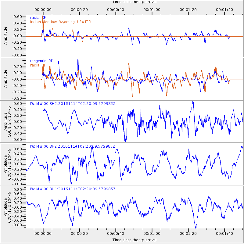
IMW Indian Meadow, Wyoming, USA - Earthquake Result Viewer
*The percent match for this event was below the threshold and hence no stack was calculated.
| Earthquake location: |
Rat Islands, Aleutian Islands |
| Earthquake latitude/longitude: |
51.1/178.8 |
| Earthquake time(UTC): |
2016/11/14 (319) 02:12:17 GMT |
| Earthquake Depth: |
34 km |
| Earthquake Magnitude: |
5.6 MWW, 5.0 ML, 5.4 ML |
| Earthquake Catalog/Contributor: |
NEIC PDE/NEIC COMCAT |
|
| Network: |
IW Intermountain West |
| Station: |
IMW Indian Meadow, Wyoming, USA |
| Lat/Lon: |
43.90 N/110.94 W |
| Elevation: |
2646 m |
|
| Distance: |
46.3 deg |
| Az: |
70.112 deg |
| Baz: |
304.851 deg |
| Ray Param: |
$rayparam |
*The percent match for this event was below the threshold and hence was not used in the summary stack. |
|
| Radial Match: |
60.475967 % |
| Radial Bump: |
400 |
| Transverse Match: |
72.56988 % |
| Transverse Bump: |
400 |
| SOD ConfigId: |
1858631 |
| Insert Time: |
2016-12-01 02:47:25.323 +0000 |
| GWidth: |
2.5 |
| Max Bumps: |
400 |
| Tol: |
0.001 |
|
Signal To Noise
| Channel | StoN | STA | LTA |
| IW:IMW:00:BHZ:20161114T02:20:09.579985Z | 0.9944022 | 2.5127846E-7 | 2.5269298E-7 |
| IW:IMW:00:BH1:20161114T02:20:09.579985Z | 1.850283 | 4.2272418E-7 | 2.284646E-7 |
| IW:IMW:00:BH2:20161114T02:20:09.579985Z | 0.5184554 | 1.05542725E-7 | 2.0357147E-7 |
| Arrivals |
| Ps | |
| PpPs | |
| PsPs/PpSs | |


