You are here: Home > Network List > TA - USArray Transportable Network (new EarthScope stations) Stations List
> Station 127A Arkansas Junction, Hobbs, NM, USA > Earthquake Result Viewer
127A Arkansas Junction, Hobbs, NM, USA - Earthquake Result Viewer
| Earthquake location: |
Fiji Islands Region |
| Earthquake latitude/longitude: |
-17.3/-177.3 |
| Earthquake time(UTC): |
2008/07/19 (201) 22:39:52 GMT |
| Earthquake Depth: |
391 km |
| Earthquake Magnitude: |
5.9 MB, 6.4 MW, 6.4 MW |
| Earthquake Catalog/Contributor: |
WHDF/NEIC |
|
| Network: |
TA USArray Transportable Network (new EarthScope stations) |
| Station: |
127A Arkansas Junction, Hobbs, NM, USA |
| Lat/Lon: |
32.68 N/103.36 W |
| Elevation: |
1160 m |
|
| Distance: |
86.4 deg |
| Az: |
54.307 deg |
| Baz: |
246.894 deg |
| Ray Param: |
0.04309129 |
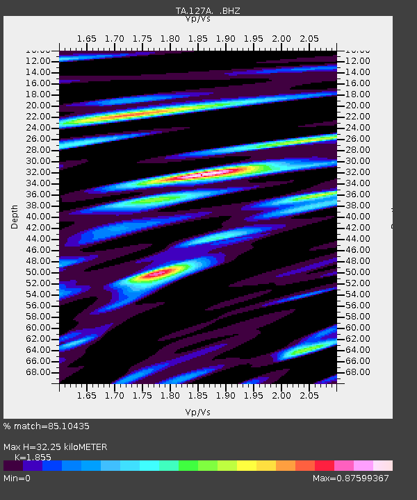
| Estimated Moho Depth: |
32.25 km |
| Estimated Crust Vp/Vs: |
1.86 |
| Assumed Crust Vp: |
6.129 km/s |
| Estimated Crust Vs: |
3.304 km/s |
| Estimated Crust Poisson's Ratio: |
0.30 |
|
| Radial Match: |
85.10435 % |
| Radial Bump: |
400 |
| Transverse Match: |
56.690685 % |
| Transverse Bump: |
400 |
| SOD ConfigId: |
2504 |
| Insert Time: |
2010-03-06 23:33:53.307 +0000 |
| GWidth: |
2.5 |
| Max Bumps: |
400 |
| Tol: |
0.001 |
|

Signal To Noise
| Channel | StoN | STA | LTA |
| TA:127A: :BHZ:20080719T22:51:20.600024Z | 14.538989 | 1.7360511E-6 | 1.194066E-7 |
| TA:127A: :BHN:20080719T22:51:20.600024Z | 1.8930337 | 2.897677E-7 | 1.5307056E-7 |
| TA:127A: :BHE:20080719T22:51:20.600024Z | 9.014338 | 6.2104664E-7 | 6.8895424E-8 |
| Arrivals |
| Ps | 4.6 SECOND |
| PpPs | 15 SECOND |
| PsPs/PpSs | 19 SECOND |


