You are here: Home > Network List > TA - USArray Transportable Network (new EarthScope stations) Stations List
> Station 127A Arkansas Junction, Hobbs, NM, USA > Earthquake Result Viewer
127A Arkansas Junction, Hobbs, NM, USA - Earthquake Result Viewer

| Earthquake location: |
Andreanof Islands, Aleutian Is. |
| Earthquake latitude/longitude: |
52.2/-175.7 |
| Earthquake time(UTC): |
2008/08/07 (220) 18:30:03 GMT |
| Earthquake Depth: |
12 km |
| Earthquake Magnitude: |
5.6 MB, 5.5 MS, 5.8 MW, 5.8 MW |
| Earthquake Catalog/Contributor: |
WHDF/NEIC |
|
| Network: |
TA USArray Transportable Network (new EarthScope stations) |
| Station: |
127A Arkansas Junction, Hobbs, NM, USA |
| Lat/Lon: |
32.68 N/103.36 W |
| Elevation: |
1160 m |
|
| Distance: |
54.5 deg |
| Az: |
80.903 deg |
| Baz: |
313.883 deg |
| Ray Param: |
0.0654329 |
| Estimated Moho Depth: |
61.25 km |
| Estimated Crust Vp/Vs: |
1.63 |
| Assumed Crust Vp: |
6.129 km/s |
| Estimated Crust Vs: |
3.76 km/s |
| Estimated Crust Poisson's Ratio: |
0.20 |
|
| Radial Match: |
84.80569 % |
| Radial Bump: |
400 |
| Transverse Match: |
67.235146 % |
| Transverse Bump: |
400 |
| SOD ConfigId: |
2504 |
| Insert Time: |
2010-03-06 23:33:58.158 +0000 |
| GWidth: |
2.5 |
| Max Bumps: |
400 |
| Tol: |
0.001 |
|
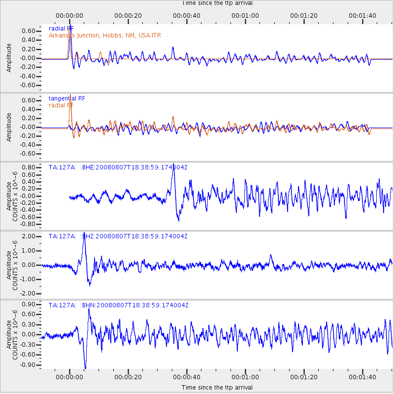
Signal To Noise
| Channel | StoN | STA | LTA |
| TA:127A: :BHZ:20080807T18:38:59.174004Z | 6.7486978 | 5.479753E-7 | 8.1197186E-8 |
| TA:127A: :BHN:20080807T18:38:59.174004Z | 2.4581997 | 1.5212562E-7 | 6.188497E-8 |
| TA:127A: :BHE:20080807T18:38:59.174004Z | 1.6449467 | 1.3018136E-7 | 7.914018E-8 |
| Arrivals |
| Ps | 6.6 SECOND |
| PpPs | 25 SECOND |
| PsPs/PpSs | 32 SECOND |


