You are here: Home > Network List > TA - USArray Transportable Network (new EarthScope stations) Stations List
> Station 127A Arkansas Junction, Hobbs, NM, USA > Earthquake Result Viewer
127A Arkansas Junction, Hobbs, NM, USA - Earthquake Result Viewer
| Earthquake location: |
Santa Cruz Islands Region |
| Earthquake latitude/longitude: |
-11.0/164.5 |
| Earthquake time(UTC): |
2008/07/19 (201) 09:27:01 GMT |
| Earthquake Depth: |
11 km |
| Earthquake Magnitude: |
6.1 MB, 6.4 MS, 6.6 MW, 6.6 MW |
| Earthquake Catalog/Contributor: |
WHDF/NEIC |
|
| Network: |
TA USArray Transportable Network (new EarthScope stations) |
| Station: |
127A Arkansas Junction, Hobbs, NM, USA |
| Lat/Lon: |
32.68 N/103.36 W |
| Elevation: |
1160 m |
|
| Distance: |
97.7 deg |
| Az: |
58.252 deg |
| Baz: |
261.839 deg |
| Ray Param: |
0.040146627 |
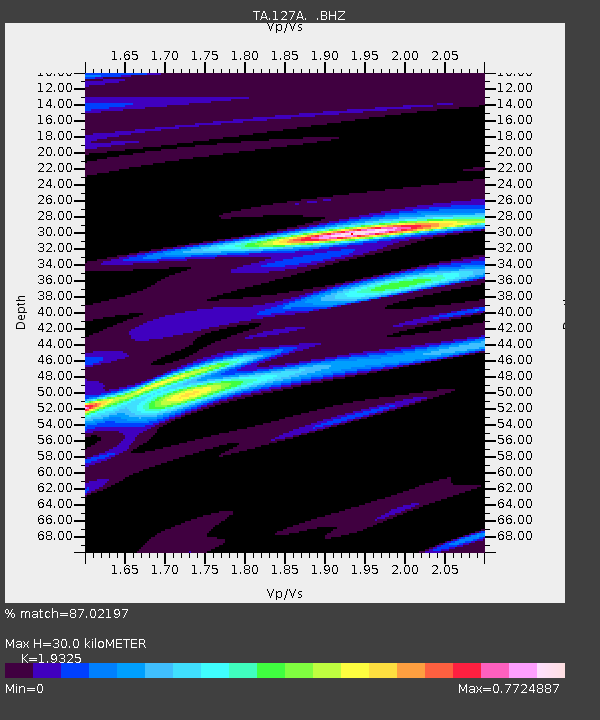
| Estimated Moho Depth: |
30.0 km |
| Estimated Crust Vp/Vs: |
1.93 |
| Assumed Crust Vp: |
6.129 km/s |
| Estimated Crust Vs: |
3.171 km/s |
| Estimated Crust Poisson's Ratio: |
0.32 |
|
| Radial Match: |
87.02197 % |
| Radial Bump: |
400 |
| Transverse Match: |
57.606285 % |
| Transverse Bump: |
400 |
| SOD ConfigId: |
2658 |
| Insert Time: |
2010-03-06 23:34:20.996 +0000 |
| GWidth: |
2.5 |
| Max Bumps: |
400 |
| Tol: |
0.001 |
|

Signal To Noise
| Channel | StoN | STA | LTA |
| TA:127A: :BHZ:20080719T09:40:04.249001Z | 7.204198 | 5.897947E-7 | 8.18682E-8 |
| TA:127A: :BHN:20080719T09:40:04.249001Z | 1.2499448 | 8.6978204E-8 | 6.958564E-8 |
| TA:127A: :BHE:20080719T09:40:04.249001Z | 2.511974 | 1.9267118E-7 | 7.6701106E-8 |
| Arrivals |
| Ps | 4.6 SECOND |
| PpPs | 14 SECOND |
| PsPs/PpSs | 19 SECOND |


