You are here: Home > Network List > C0 - Colorado Geological Survey Seismic Network Stations List
> Station LAMA Lamar Colorado > Earthquake Result Viewer
LAMA Lamar Colorado - Earthquake Result Viewer
| Earthquake location: |
Off Coast Of Central Chile |
| Earthquake latitude/longitude: |
-30.0/-72.2 |
| Earthquake time(UTC): |
2019/06/14 (165) 00:19:10 GMT |
| Earthquake Depth: |
10 km |
| Earthquake Magnitude: |
6.5 Mww |
| Earthquake Catalog/Contributor: |
NEIC PDE/us |
|
| Network: |
C0 Colorado Geological Survey Seismic Network |
| Station: |
LAMA Lamar Colorado |
| Lat/Lon: |
38.27 N/102.65 W |
| Elevation: |
1182 m |
|
| Distance: |
73.7 deg |
| Az: |
335.416 deg |
| Baz: |
152.72 deg |
| Ray Param: |
0.052839648 |
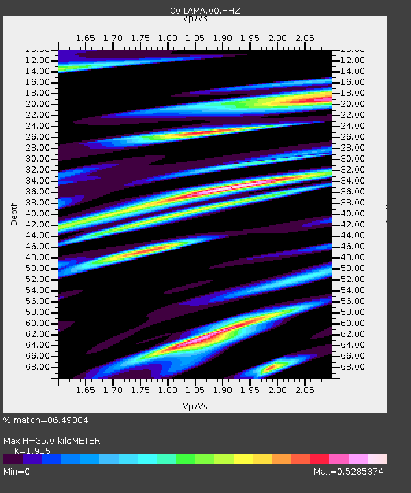
| Estimated Moho Depth: |
35.0 km |
| Estimated Crust Vp/Vs: |
1.91 |
| Assumed Crust Vp: |
6.242 km/s |
| Estimated Crust Vs: |
3.26 km/s |
| Estimated Crust Poisson's Ratio: |
0.31 |
|
| Radial Match: |
86.49304 % |
| Radial Bump: |
354 |
| Transverse Match: |
45.693436 % |
| Transverse Bump: |
400 |
| SOD ConfigId: |
18369291 |
| Insert Time: |
2019-06-28 00:19:59.826 +0000 |
| GWidth: |
2.5 |
| Max Bumps: |
400 |
| Tol: |
0.001 |
|

Signal To Noise
| Channel | StoN | STA | LTA |
| C0:LAMA:00:HHZ:20190614T00:30:13.180015Z | 2.4052486 | 2.0153298E-7 | 8.3788834E-8 |
| C0:LAMA:00:HHN:20190614T00:30:13.180015Z | 1.9135975 | 1.2158809E-7 | 6.353901E-8 |
| C0:LAMA:00:HHE:20190614T00:30:13.180015Z | 1.5121837 | 9.7678566E-8 | 6.4594374E-8 |
| Arrivals |
| Ps | 5.3 SECOND |
| PpPs | 16 SECOND |
| PsPs/PpSs | 21 SECOND |


