You are here: Home > Network List > TA - USArray Transportable Network (new EarthScope stations) Stations List
> Station 127A Arkansas Junction, Hobbs, NM, USA > Earthquake Result Viewer
127A Arkansas Junction, Hobbs, NM, USA - Earthquake Result Viewer
| Earthquake location: |
Andreanof Islands, Aleutian Is. |
| Earthquake latitude/longitude: |
51.9/-179.2 |
| Earthquake time(UTC): |
2008/04/16 (107) 05:54:19 GMT |
| Earthquake Depth: |
13 km |
| Earthquake Magnitude: |
6.1 MB, 6.5 MS, 6.6 MW, 6.6 MW |
| Earthquake Catalog/Contributor: |
WHDF/NEIC |
|
| Network: |
TA USArray Transportable Network (new EarthScope stations) |
| Station: |
127A Arkansas Junction, Hobbs, NM, USA |
| Lat/Lon: |
32.68 N/103.36 W |
| Elevation: |
1160 m |
|
| Distance: |
56.6 deg |
| Az: |
78.199 deg |
| Baz: |
313.988 deg |
| Ray Param: |
0.06399895 |
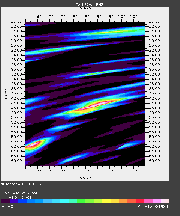
| Estimated Moho Depth: |
45.25 km |
| Estimated Crust Vp/Vs: |
1.87 |
| Assumed Crust Vp: |
6.129 km/s |
| Estimated Crust Vs: |
3.282 km/s |
| Estimated Crust Poisson's Ratio: |
0.30 |
|
| Radial Match: |
91.769035 % |
| Radial Bump: |
400 |
| Transverse Match: |
70.09827 % |
| Transverse Bump: |
400 |
| SOD ConfigId: |
2504 |
| Insert Time: |
2010-03-06 23:35:19.614 +0000 |
| GWidth: |
2.5 |
| Max Bumps: |
400 |
| Tol: |
0.001 |
|
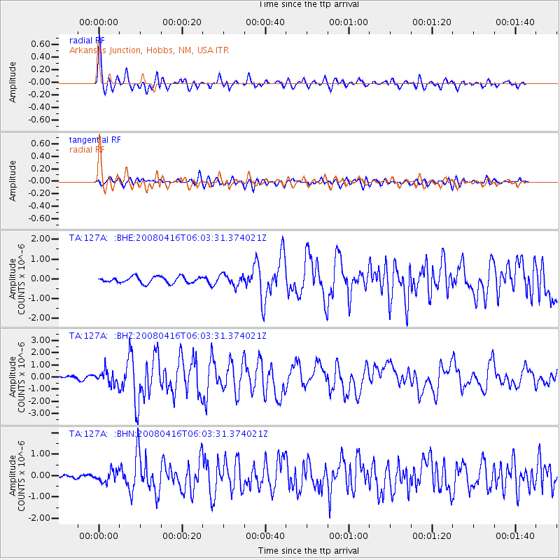
Signal To Noise
| Channel | StoN | STA | LTA |
| TA:127A: :BHZ:20080416T06:03:31.374021Z | 3.7472963 | 5.662088E-7 | 1.5109795E-7 |
| TA:127A: :BHN:20080416T06:03:31.374021Z | 1.9097264 | 2.7071218E-7 | 1.4175443E-7 |
| TA:127A: :BHE:20080416T06:03:31.374021Z | 1.7641592 | 2.7926862E-7 | 1.5830126E-7 |
| Arrivals |
| Ps | 6.7 SECOND |
| PpPs | 20 SECOND |
| PsPs/PpSs | 27 SECOND |


