You are here: Home > Network List > US - United States National Seismic Network Stations List
> Station HAWA Hanford, Washington, USA > Earthquake Result Viewer
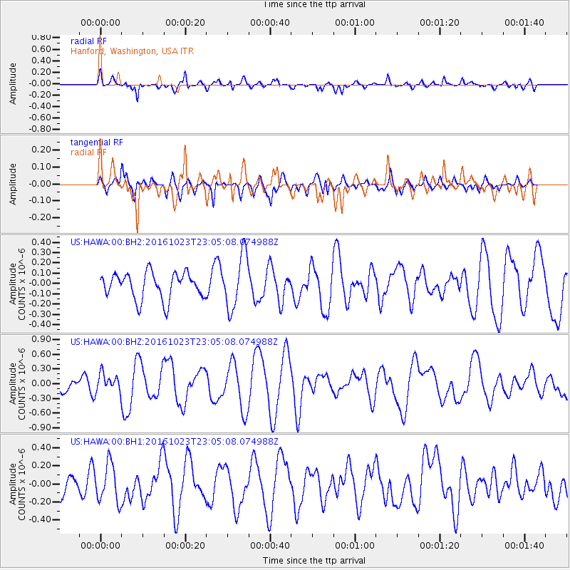
HAWA Hanford, Washington, USA - Earthquake Result Viewer
*The percent match for this event was below the threshold and hence no stack was calculated.
| Earthquake location: |
Near Coast Of Jalisco, Mexico |
| Earthquake latitude/longitude: |
18.9/-104.6 |
| Earthquake time(UTC): |
2016/10/23 (297) 22:59:29 GMT |
| Earthquake Depth: |
12 km |
| Earthquake Magnitude: |
5.6 MWW, 5.4 MWB |
| Earthquake Catalog/Contributor: |
NEIC PDE/NEIC COMCAT |
|
| Network: |
US United States National Seismic Network |
| Station: |
HAWA Hanford, Washington, USA |
| Lat/Lon: |
46.39 N/119.53 W |
| Elevation: |
364 m |
|
| Distance: |
30.0 deg |
| Az: |
339.09 deg |
| Baz: |
150.782 deg |
| Ray Param: |
$rayparam |
*The percent match for this event was below the threshold and hence was not used in the summary stack. |
|
| Radial Match: |
75.967445 % |
| Radial Bump: |
400 |
| Transverse Match: |
47.748608 % |
| Transverse Bump: |
400 |
| SOD ConfigId: |
1858631 |
| Insert Time: |
2016-12-01 04:57:19.861 +0000 |
| GWidth: |
2.5 |
| Max Bumps: |
400 |
| Tol: |
0.001 |
|
Signal To Noise
| Channel | StoN | STA | LTA |
| US:HAWA:00:BHZ:20161023T23:05:08.074988Z | 0.8903578 | 1.7776428E-7 | 1.9965489E-7 |
| US:HAWA:00:BH1:20161023T23:05:08.074988Z | 1.5495541 | 2.187756E-7 | 1.4118616E-7 |
| US:HAWA:00:BH2:20161023T23:05:08.074988Z | 2.128509 | 2.7023478E-7 | 1.2695966E-7 |
| Arrivals |
| Ps | |
| PpPs | |
| PsPs/PpSs | |


