You are here: Home > Network List > TS - TERRAscope (Southern California Seismic Network) Stations List
> Station GSC Goldston, California, USA > Earthquake Result Viewer
GSC Goldston, California, USA - Earthquake Result Viewer
| Earthquake location: |
Off East Coast Of Kamchatka |
| Earthquake latitude/longitude: |
52.9/159.7 |
| Earthquake time(UTC): |
1992/03/05 (065) 14:39:10 GMT |
| Earthquake Depth: |
44 km |
| Earthquake Magnitude: |
6.5 MB, 6.1 MS, 5.8 UNKNOWN |
| Earthquake Catalog/Contributor: |
WHDF/NEIC |
|
| Network: |
TS TERRAscope (Southern California Seismic Network) |
| Station: |
GSC Goldston, California, USA |
| Lat/Lon: |
35.30 N/116.81 W |
| Elevation: |
990 m |
|
| Distance: |
59.1 deg |
| Az: |
71.326 deg |
| Baz: |
315.445 deg |
| Ray Param: |
0.062336136 |
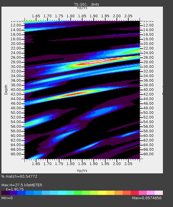
| Estimated Moho Depth: |
27.5 km |
| Estimated Crust Vp/Vs: |
1.92 |
| Assumed Crust Vp: |
6.276 km/s |
| Estimated Crust Vs: |
3.273 km/s |
| Estimated Crust Poisson's Ratio: |
0.31 |
|
| Radial Match: |
80.54772 % |
| Radial Bump: |
400 |
| Transverse Match: |
75.3943 % |
| Transverse Bump: |
400 |
| SOD ConfigId: |
16938 |
| Insert Time: |
2010-02-26 14:15:27.404 +0000 |
| GWidth: |
2.5 |
| Max Bumps: |
400 |
| Tol: |
0.001 |
|

Signal To Noise
| Channel | StoN | STA | LTA |
| TS:GSC: :BHN:19920305T14:48:35.213Z | 3.0382595 | 3.0087193E-7 | 9.902772E-8 |
| TS:GSC: :BHE:19920305T14:48:35.213Z | 1.4198687 | 2.5712043E-7 | 1.8108747E-7 |
| TS:GSC: :BHZ:19920305T14:48:35.213Z | 3.1224978 | 6.6727534E-7 | 2.1369922E-7 |
| Arrivals |
| Ps | 4.2 SECOND |
| PpPs | 12 SECOND |
| PsPs/PpSs | 16 SECOND |


