You are here: Home > Network List > NE - New England Seismic Network Stations List
> Station EMMW Machias, ME, USA > Earthquake Result Viewer
EMMW Machias, ME, USA - Earthquake Result Viewer
| Earthquake location: |
Off Coast Of Central Chile |
| Earthquake latitude/longitude: |
-30.0/-72.2 |
| Earthquake time(UTC): |
2019/06/14 (165) 00:19:10 GMT |
| Earthquake Depth: |
10 km |
| Earthquake Magnitude: |
6.5 Mww |
| Earthquake Catalog/Contributor: |
NEIC PDE/us |
|
| Network: |
NE New England Seismic Network |
| Station: |
EMMW Machias, ME, USA |
| Lat/Lon: |
44.71 N/67.46 W |
| Elevation: |
35 m |
|
| Distance: |
74.5 deg |
| Az: |
3.479 deg |
| Baz: |
184.232 deg |
| Ray Param: |
0.052283216 |
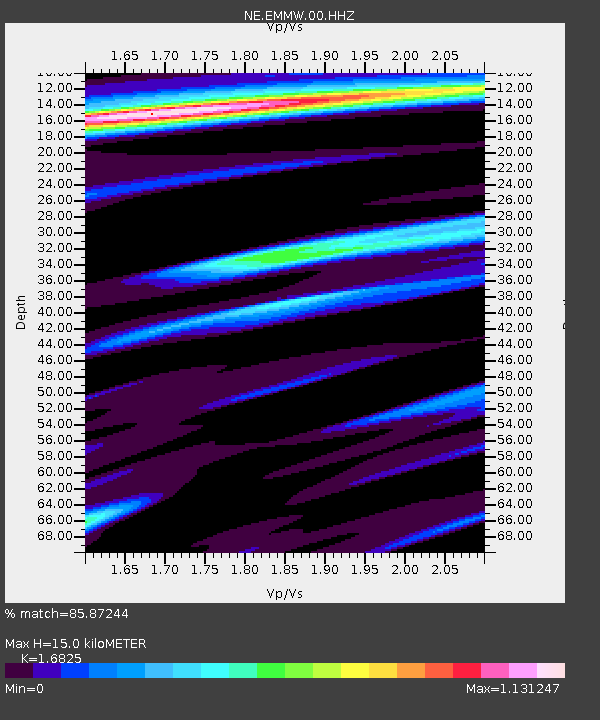
| Estimated Moho Depth: |
15.0 km |
| Estimated Crust Vp/Vs: |
1.68 |
| Assumed Crust Vp: |
6.419 km/s |
| Estimated Crust Vs: |
3.815 km/s |
| Estimated Crust Poisson's Ratio: |
0.23 |
|
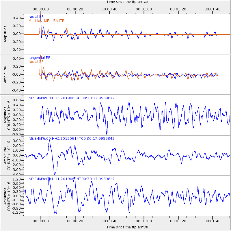
| Radial Match: |
85.87244 % |
| Radial Bump: |
400 |
| Transverse Match: |
56.504013 % |
| Transverse Bump: |
400 |
| SOD ConfigId: |
18369291 |
| Insert Time: |
2019-06-28 00:24:02.219 +0000 |
| GWidth: |
2.5 |
| Max Bumps: |
400 |
| Tol: |
0.001 |
|
Signal To Noise
| Channel | StoN | STA | LTA |
| NE:EMMW:00:HHZ:20190614T00:30:17.998984Z | 3.2129781 | 8.1671857E-7 | 2.5419362E-7 |
| NE:EMMW:00:HH1:20190614T00:30:17.998984Z | 2.3912308 | 5.160567E-7 | 2.1581215E-7 |
| NE:EMMW:00:HH2:20190614T00:30:17.998984Z | 1.7629607 | 2.9622836E-7 | 1.6802892E-7 |
| Arrivals |
| Ps | 1.7 SECOND |
| PpPs | 6.1 SECOND |
| PsPs/PpSs | 7.7 SECOND |


