You are here: Home > Network List > TA - USArray Transportable Network (new EarthScope stations) Stations List
> Station 127A Arkansas Junction, Hobbs, NM, USA > Earthquake Result Viewer
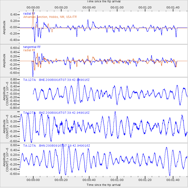
127A Arkansas Junction, Hobbs, NM, USA - Earthquake Result Viewer
*The percent match for this event was below the threshold and hence no stack was calculated.
| Earthquake location: |
Central Mid-Atlantic Ridge |
| Earthquake latitude/longitude: |
0.9/-29.0 |
| Earthquake time(UTC): |
2008/09/16 (260) 07:28:25 GMT |
| Earthquake Depth: |
10 km |
| Earthquake Magnitude: |
5.8 MW, 5.2 MS, 5.2 MB, 5.8 MW |
| Earthquake Catalog/Contributor: |
WHDF/NEIC |
|
| Network: |
TA USArray Transportable Network (new EarthScope stations) |
| Station: |
127A Arkansas Junction, Hobbs, NM, USA |
| Lat/Lon: |
32.68 N/103.36 W |
| Elevation: |
1160 m |
|
| Distance: |
76.4 deg |
| Az: |
303.311 deg |
| Baz: |
97.786 deg |
| Ray Param: |
$rayparam |
*The percent match for this event was below the threshold and hence was not used in the summary stack. |
|
| Radial Match: |
73.4381 % |
| Radial Bump: |
369 |
| Transverse Match: |
66.67582 % |
| Transverse Bump: |
400 |
| SOD ConfigId: |
2560 |
| Insert Time: |
2010-03-06 23:36:49.052 +0000 |
| GWidth: |
2.5 |
| Max Bumps: |
400 |
| Tol: |
0.001 |
|
Signal To Noise
| Channel | StoN | STA | LTA |
| TA:127A: :BHZ:20080916T07:39:42.949016Z | 1.323206 | 3.2204554E-7 | 2.4338277E-7 |
| TA:127A: :BHN:20080916T07:39:42.949016Z | 0.77177244 | 1.5866054E-7 | 2.0557943E-7 |
| TA:127A: :BHE:20080916T07:39:42.949016Z | 2.0988307 | 4.5425227E-7 | 2.1643113E-7 |
| Arrivals |
| Ps | |
| PpPs | |
| PsPs/PpSs | |


