You are here: Home > Network List > TA - USArray Transportable Network (new EarthScope stations) Stations List
> Station 325A Bean Ranch, Sierra Blanca, TX, USA > Earthquake Result Viewer
325A Bean Ranch, Sierra Blanca, TX, USA - Earthquake Result Viewer
| Earthquake location: |
Southern Peru |
| Earthquake latitude/longitude: |
-16.0/-71.7 |
| Earthquake time(UTC): |
2008/07/08 (190) 09:13:07 GMT |
| Earthquake Depth: |
123 km |
| Earthquake Magnitude: |
5.8 MB, 6.2 MW, 6.2 MW |
| Earthquake Catalog/Contributor: |
WHDF/NEIC |
|
| Network: |
TA USArray Transportable Network (new EarthScope stations) |
| Station: |
325A Bean Ranch, Sierra Blanca, TX, USA |
| Lat/Lon: |
31.37 N/104.97 W |
| Elevation: |
1666 m |
|
| Distance: |
56.9 deg |
| Az: |
325.973 deg |
| Baz: |
141.007 deg |
| Ray Param: |
0.06347763 |
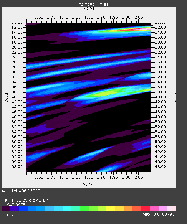
| Estimated Moho Depth: |
12.25 km |
| Estimated Crust Vp/Vs: |
2.10 |
| Assumed Crust Vp: |
6.361 km/s |
| Estimated Crust Vs: |
3.032 km/s |
| Estimated Crust Poisson's Ratio: |
0.35 |
|
| Radial Match: |
86.15838 % |
| Radial Bump: |
400 |
| Transverse Match: |
73.111694 % |
| Transverse Bump: |
400 |
| SOD ConfigId: |
2504 |
| Insert Time: |
2010-03-06 23:36:56.528 +0000 |
| GWidth: |
2.5 |
| Max Bumps: |
400 |
| Tol: |
0.001 |
|
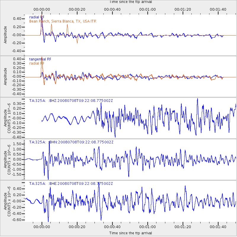
Signal To Noise
| Channel | StoN | STA | LTA |
| TA:325A: :BHN:20080708T09:22:08.775002Z | 11.226834 | 8.049503E-7 | 7.169878E-8 |
| TA:325A: :BHE:20080708T09:22:08.775002Z | 3.1528835 | 2.4888436E-7 | 7.893865E-8 |
| TA:325A: :BHZ:20080708T09:22:08.775002Z | 2.5331633 | 1.388536E-7 | 5.4814304E-8 |
| Arrivals |
| Ps | 2.2 SECOND |
| PpPs | 5.7 SECOND |
| PsPs/PpSs | 7.9 SECOND |


