You are here: Home > Network List > TA - USArray Transportable Network (new EarthScope stations) Stations List
> Station 325A Bean Ranch, Sierra Blanca, TX, USA > Earthquake Result Viewer
325A Bean Ranch, Sierra Blanca, TX, USA - Earthquake Result Viewer
| Earthquake location: |
Hokkaido, Japan Region |
| Earthquake latitude/longitude: |
41.9/143.8 |
| Earthquake time(UTC): |
2008/09/11 (255) 00:20:50 GMT |
| Earthquake Depth: |
25 km |
| Earthquake Magnitude: |
6.1 MB, 7.0 MS, 6.8 MW, 6.8 MW |
| Earthquake Catalog/Contributor: |
WHDF/NEIC |
|
| Network: |
TA USArray Transportable Network (new EarthScope stations) |
| Station: |
325A Bean Ranch, Sierra Blanca, TX, USA |
| Lat/Lon: |
31.37 N/104.97 W |
| Elevation: |
1666 m |
|
| Distance: |
83.5 deg |
| Az: |
53.34 deg |
| Baz: |
315.555 deg |
| Ray Param: |
0.046103347 |
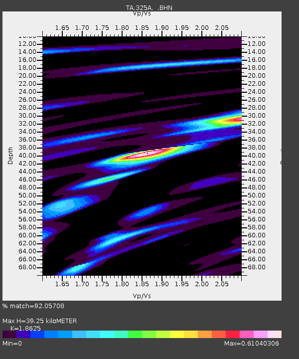
| Estimated Moho Depth: |
39.25 km |
| Estimated Crust Vp/Vs: |
1.86 |
| Assumed Crust Vp: |
6.361 km/s |
| Estimated Crust Vs: |
3.415 km/s |
| Estimated Crust Poisson's Ratio: |
0.30 |
|
| Radial Match: |
92.05708 % |
| Radial Bump: |
285 |
| Transverse Match: |
86.96378 % |
| Transverse Bump: |
400 |
| SOD ConfigId: |
2560 |
| Insert Time: |
2010-03-06 23:37:19.694 +0000 |
| GWidth: |
2.5 |
| Max Bumps: |
400 |
| Tol: |
0.001 |
|

Signal To Noise
| Channel | StoN | STA | LTA |
| TA:325A: :BHN:20080911T00:32:45.200029Z | 2.9872463 | 6.573688E-7 | 2.2005847E-7 |
| TA:325A: :BHE:20080911T00:32:45.200029Z | 1.0021148 | 1.9972319E-7 | 1.9930172E-7 |
| TA:325A: :BHZ:20080911T00:32:45.200029Z | 1.7148056 | 2.5386294E-7 | 1.4804182E-7 |
| Arrivals |
| Ps | 5.5 SECOND |
| PpPs | 17 SECOND |
| PsPs/PpSs | 23 SECOND |


