You are here: Home > Network List > TA - USArray Transportable Network (new EarthScope stations) Stations List
> Station 325A Bean Ranch, Sierra Blanca, TX, USA > Earthquake Result Viewer
325A Bean Ranch, Sierra Blanca, TX, USA - Earthquake Result Viewer
| Earthquake location: |
Central East Pacific Rise |
| Earthquake latitude/longitude: |
-4.6/-106.0 |
| Earthquake time(UTC): |
2008/09/18 (262) 01:41:02 GMT |
| Earthquake Depth: |
10 km |
| Earthquake Magnitude: |
5.5 MB, 5.7 MS, 6.0 MW, 6.0 MW |
| Earthquake Catalog/Contributor: |
WHDF/NEIC |
|
| Network: |
TA USArray Transportable Network (new EarthScope stations) |
| Station: |
325A Bean Ranch, Sierra Blanca, TX, USA |
| Lat/Lon: |
31.37 N/104.97 W |
| Elevation: |
1666 m |
|
| Distance: |
35.7 deg |
| Az: |
1.507 deg |
| Baz: |
181.756 deg |
| Ray Param: |
0.07706152 |
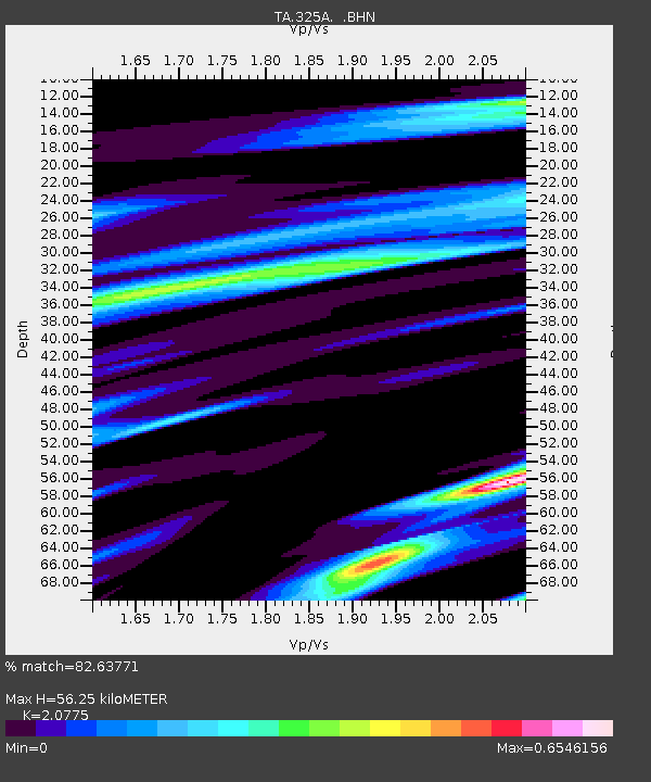
| Estimated Moho Depth: |
56.25 km |
| Estimated Crust Vp/Vs: |
2.08 |
| Assumed Crust Vp: |
6.361 km/s |
| Estimated Crust Vs: |
3.062 km/s |
| Estimated Crust Poisson's Ratio: |
0.35 |
|
| Radial Match: |
82.63771 % |
| Radial Bump: |
311 |
| Transverse Match: |
54.937317 % |
| Transverse Bump: |
302 |
| SOD ConfigId: |
2560 |
| Insert Time: |
2010-03-06 23:37:23.065 +0000 |
| GWidth: |
2.5 |
| Max Bumps: |
400 |
| Tol: |
0.001 |
|
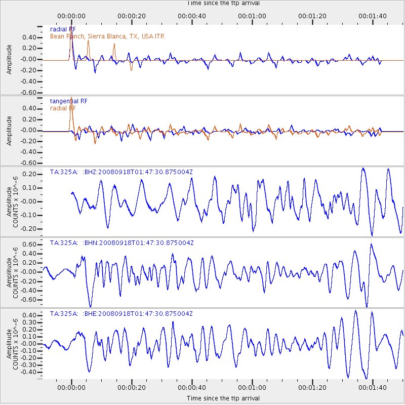
Signal To Noise
| Channel | StoN | STA | LTA |
| TA:325A: :BHN:20080918T01:47:30.875004Z | 2.6432135 | 1.8517646E-7 | 7.0057325E-8 |
| TA:325A: :BHE:20080918T01:47:30.875004Z | 2.8075082 | 1.1393251E-7 | 4.0581362E-8 |
| TA:325A: :BHZ:20080918T01:47:30.875004Z | 0.84241223 | 6.534921E-8 | 7.7573915E-8 |
| Arrivals |
| Ps | 10 SECOND |
| PpPs | 26 SECOND |
| PsPs/PpSs | 36 SECOND |


