You are here: Home > Network List > TA - USArray Transportable Network (new EarthScope stations) Stations List
> Station 325A Bean Ranch, Sierra Blanca, TX, USA > Earthquake Result Viewer
325A Bean Ranch, Sierra Blanca, TX, USA - Earthquake Result Viewer
| Earthquake location: |
South Of Tonga Islands |
| Earthquake latitude/longitude: |
-24.1/-175.2 |
| Earthquake time(UTC): |
2009/11/02 (306) 10:47:13 GMT |
| Earthquake Depth: |
9.0 km |
| Earthquake Magnitude: |
6.1 MB, 6.1 MS, 6.2 MW, 6.1 MW |
| Earthquake Catalog/Contributor: |
WHDF/NEIC |
|
| Network: |
TA USArray Transportable Network (new EarthScope stations) |
| Station: |
325A Bean Ranch, Sierra Blanca, TX, USA |
| Lat/Lon: |
31.37 N/104.97 W |
| Elevation: |
1666 m |
|
| Distance: |
86.9 deg |
| Az: |
53.706 deg |
| Baz: |
239.425 deg |
| Ray Param: |
0.043721307 |
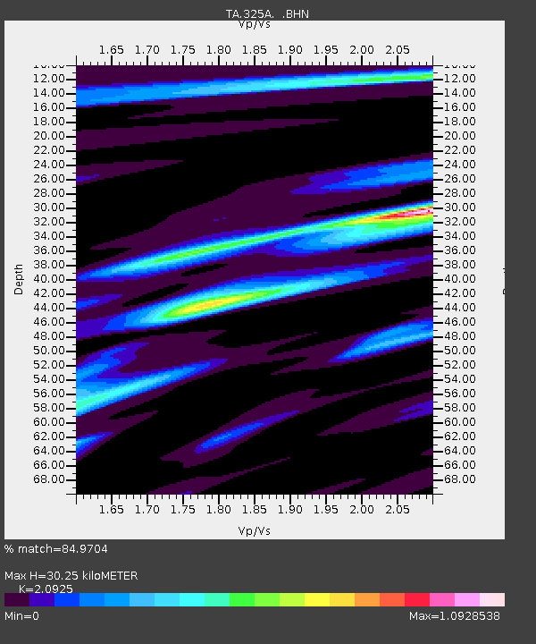
| Estimated Moho Depth: |
30.25 km |
| Estimated Crust Vp/Vs: |
2.09 |
| Assumed Crust Vp: |
6.361 km/s |
| Estimated Crust Vs: |
3.04 km/s |
| Estimated Crust Poisson's Ratio: |
0.35 |
|
| Radial Match: |
84.9704 % |
| Radial Bump: |
400 |
| Transverse Match: |
65.605064 % |
| Transverse Bump: |
343 |
| SOD ConfigId: |
2622 |
| Insert Time: |
2010-03-06 23:37:45.925 +0000 |
| GWidth: |
2.5 |
| Max Bumps: |
400 |
| Tol: |
0.001 |
|

Signal To Noise
| Channel | StoN | STA | LTA |
| TA:325A: :BHN:20091102T10:59:26.724009Z | 13.717126 | 1.8580636E-6 | 1.3545575E-7 |
| TA:325A: :BHE:20091102T10:59:26.724009Z | 1.6489152 | 3.2824468E-7 | 1.9906705E-7 |
| TA:325A: :BHZ:20091102T10:59:26.724009Z | 2.9060707 | 5.76884E-7 | 1.9850995E-7 |
| Arrivals |
| Ps | 5.3 SECOND |
| PpPs | 14 SECOND |
| PsPs/PpSs | 20 SECOND |


