You are here: Home > Network List > TA - USArray Transportable Network (new EarthScope stations) Stations List
> Station 325A Bean Ranch, Sierra Blanca, TX, USA > Earthquake Result Viewer
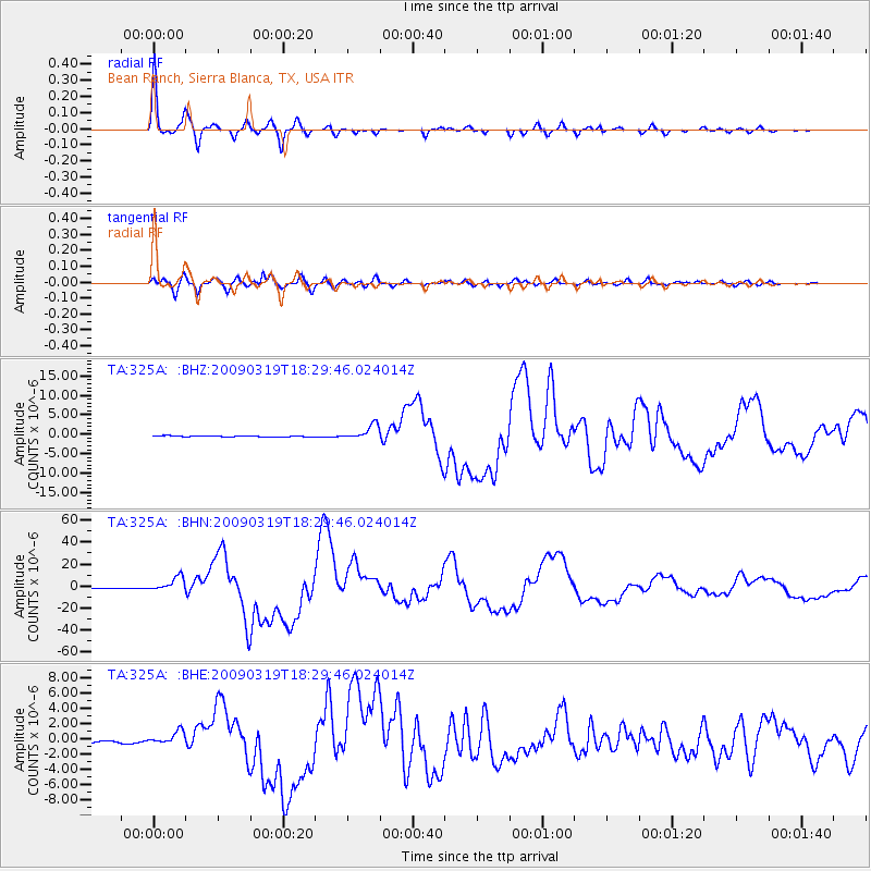
325A Bean Ranch, Sierra Blanca, TX, USA - Earthquake Result Viewer

| Earthquake location: |
Tonga Islands Region |
| Earthquake latitude/longitude: |
-23.0/-174.7 |
| Earthquake time(UTC): |
2009/03/19 (078) 18:17:40 GMT |
| Earthquake Depth: |
34 km |
| Earthquake Magnitude: |
7.0 MB, 7.6 MS, 7.6 MW, 7.6 MW |
| Earthquake Catalog/Contributor: |
WHDF/NEIC |
|
| Network: |
TA USArray Transportable Network (new EarthScope stations) |
| Station: |
325A Bean Ranch, Sierra Blanca, TX, USA |
| Lat/Lon: |
31.37 N/104.97 W |
| Elevation: |
1666 m |
|
| Distance: |
85.9 deg |
| Az: |
53.538 deg |
| Baz: |
240.008 deg |
| Ray Param: |
0.04440448 |
| Estimated Moho Depth: |
31.25 km |
| Estimated Crust Vp/Vs: |
2.04 |
| Assumed Crust Vp: |
6.361 km/s |
| Estimated Crust Vs: |
3.122 km/s |
| Estimated Crust Poisson's Ratio: |
0.34 |
|
| Radial Match: |
98.31113 % |
| Radial Bump: |
311 |
| Transverse Match: |
94.579384 % |
| Transverse Bump: |
400 |
| SOD ConfigId: |
2658 |
| Insert Time: |
2010-03-06 23:38:07.147 +0000 |
| GWidth: |
2.5 |
| Max Bumps: |
400 |
| Tol: |
0.001 |
|
Signal To Noise
| Channel | StoN | STA | LTA |
| TA:325A: :BHN:20090319T18:29:46.024014Z | 23.03736 | 6.632174E-6 | 2.878878E-7 |
| TA:325A: :BHE:20090319T18:29:46.024014Z | 6.1537647 | 8.763687E-7 | 1.424118E-7 |
| TA:325A: :BHZ:20090319T18:29:46.024014Z | 13.257856 | 1.8926016E-6 | 1.4275321E-7 |
| Arrivals |
| Ps | 5.2 SECOND |
| PpPs | 15 SECOND |
| PsPs/PpSs | 20 SECOND |


