You are here: Home > Network List > IU - Global Seismograph Network (GSN - IRIS/USGS) Stations List
> Station JOHN Johnston Island, USA > Earthquake Result Viewer
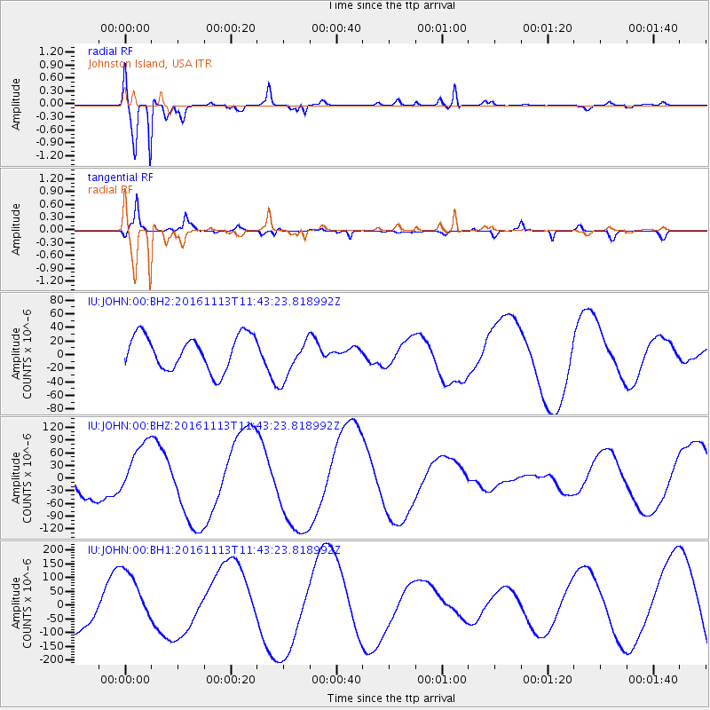
JOHN Johnston Island, USA - Earthquake Result Viewer
*The percent match for this event was below the threshold and hence no stack was calculated.
| Earthquake location: |
Off E. Coast Of S. Island, N.Z. |
| Earthquake latitude/longitude: |
-42.1/174.3 |
| Earthquake time(UTC): |
2016/11/13 (318) 11:33:45 GMT |
| Earthquake Depth: |
10 km |
| Earthquake Magnitude: |
5.8 MB |
| Earthquake Catalog/Contributor: |
NEIC PDE/NEIC COMCAT |
|
| Network: |
IU Global Seismograph Network (GSN - IRIS/USGS) |
| Station: |
JOHN Johnston Island, USA |
| Lat/Lon: |
16.73 N/169.53 W |
| Elevation: |
2.0 m |
|
| Distance: |
60.4 deg |
| Az: |
17.875 deg |
| Baz: |
193.803 deg |
| Ray Param: |
$rayparam |
*The percent match for this event was below the threshold and hence was not used in the summary stack. |
|
| Radial Match: |
89.90325 % |
| Radial Bump: |
400 |
| Transverse Match: |
72.51242 % |
| Transverse Bump: |
400 |
| SOD ConfigId: |
1858631 |
| Insert Time: |
2016-12-03 08:09:30.537 +0000 |
| GWidth: |
2.5 |
| Max Bumps: |
400 |
| Tol: |
0.001 |
|
Signal To Noise
| Channel | StoN | STA | LTA |
| IU:JOHN:00:BHZ:20161113T11:43:23.818992Z | 2.0093548 | 6.837475E-5 | 3.402821E-5 |
| IU:JOHN:00:BH1:20161113T11:43:23.818992Z | 1.6308815 | 1.0727798E-4 | 6.577914E-5 |
| IU:JOHN:00:BH2:20161113T11:43:23.818992Z | 1.2450359 | 3.1315805E-5 | 2.5152533E-5 |
| Arrivals |
| Ps | |
| PpPs | |
| PsPs/PpSs | |


