You are here: Home > Network List > TA - USArray Transportable Network (new EarthScope stations) Stations List
> Station 325A Bean Ranch, Sierra Blanca, TX, USA > Earthquake Result Viewer
325A Bean Ranch, Sierra Blanca, TX, USA - Earthquake Result Viewer
| Earthquake location: |
Southern Bolivia |
| Earthquake latitude/longitude: |
-20.1/-65.0 |
| Earthquake time(UTC): |
2008/10/12 (286) 20:55:41 GMT |
| Earthquake Depth: |
353 km |
| Earthquake Magnitude: |
6.0 MB, 6.2 MW, 6.2 MW |
| Earthquake Catalog/Contributor: |
WHDF/NEIC |
|
| Network: |
TA USArray Transportable Network (new EarthScope stations) |
| Station: |
325A Bean Ranch, Sierra Blanca, TX, USA |
| Lat/Lon: |
31.37 N/104.97 W |
| Elevation: |
1666 m |
|
| Distance: |
64.0 deg |
| Az: |
322.281 deg |
| Baz: |
137.77 deg |
| Ray Param: |
0.0580522 |
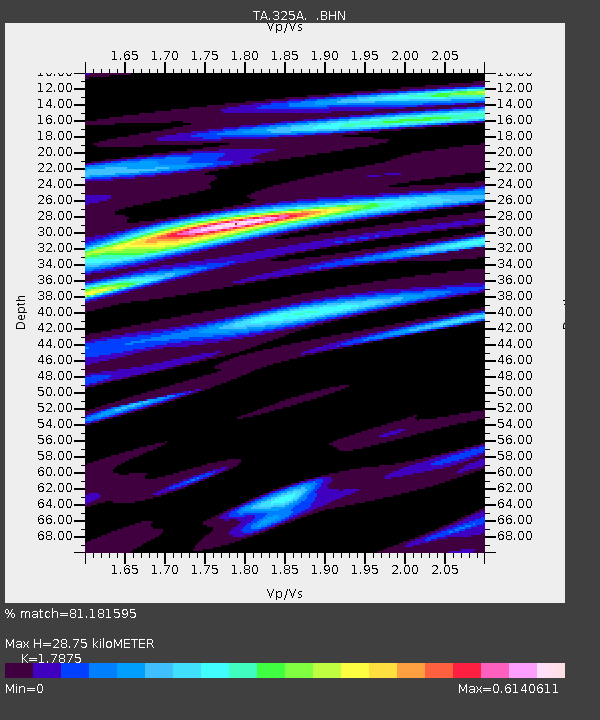
| Estimated Moho Depth: |
28.75 km |
| Estimated Crust Vp/Vs: |
1.79 |
| Assumed Crust Vp: |
6.361 km/s |
| Estimated Crust Vs: |
3.558 km/s |
| Estimated Crust Poisson's Ratio: |
0.27 |
|
| Radial Match: |
81.181595 % |
| Radial Bump: |
391 |
| Transverse Match: |
70.464386 % |
| Transverse Bump: |
400 |
| SOD ConfigId: |
2556 |
| Insert Time: |
2010-03-06 23:38:21.947 +0000 |
| GWidth: |
2.5 |
| Max Bumps: |
400 |
| Tol: |
0.001 |
|

Signal To Noise
| Channel | StoN | STA | LTA |
| TA:325A: :BHN:20081012T21:05:07.400002Z | 18.17703 | 2.6926662E-6 | 1.4813565E-7 |
| TA:325A: :BHE:20081012T21:05:07.400002Z | 4.6839724 | 7.3620004E-7 | 1.5717428E-7 |
| TA:325A: :BHZ:20081012T21:05:07.400002Z | 3.0009613 | 5.1582515E-7 | 1.7188665E-7 |
| Arrivals |
| Ps | 3.7 SECOND |
| PpPs | 12 SECOND |
| PsPs/PpSs | 16 SECOND |


