You are here: Home > Network List > TA - USArray Transportable Network (new EarthScope stations) Stations List
> Station E20K Nigu River, AK, USA > Earthquake Result Viewer
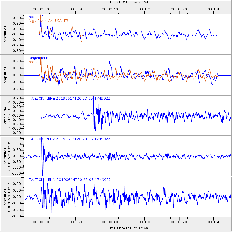
E20K Nigu River, AK, USA - Earthquake Result Viewer
*The percent match for this event was below the threshold and hence no stack was calculated.
| Earthquake location: |
Banda Sea |
| Earthquake latitude/longitude: |
-5.9/130.7 |
| Earthquake time(UTC): |
2019/06/14 (165) 20:10:52 GMT |
| Earthquake Depth: |
104 km |
| Earthquake Magnitude: |
5.6 Mww |
| Earthquake Catalog/Contributor: |
NEIC PDE/us |
|
| Network: |
TA USArray Transportable Network (new EarthScope stations) |
| Station: |
E20K Nigu River, AK, USA |
| Lat/Lon: |
68.26 N/156.19 W |
| Elevation: |
866 m |
|
| Distance: |
89.2 deg |
| Az: |
20.886 deg |
| Baz: |
252.163 deg |
| Ray Param: |
$rayparam |
*The percent match for this event was below the threshold and hence was not used in the summary stack. |
|
| Radial Match: |
62.724384 % |
| Radial Bump: |
400 |
| Transverse Match: |
57.811523 % |
| Transverse Bump: |
400 |
| SOD ConfigId: |
18369291 |
| Insert Time: |
2019-06-28 20:13:50.610 +0000 |
| GWidth: |
2.5 |
| Max Bumps: |
400 |
| Tol: |
0.001 |
|
Signal To Noise
| Channel | StoN | STA | LTA |
| TA:E20K: :BHZ:20190614T20:23:05.174992Z | 9.363368 | 5.9987605E-7 | 6.406627E-8 |
| TA:E20K: :BHN:20190614T20:23:05.174992Z | 4.850599 | 1.2186146E-7 | 2.5122972E-8 |
| TA:E20K: :BHE:20190614T20:23:05.174992Z | 5.048736 | 1.650859E-7 | 3.269846E-8 |
| Arrivals |
| Ps | |
| PpPs | |
| PsPs/PpSs | |


