You are here: Home > Network List > TA - USArray Transportable Network (new EarthScope stations) Stations List
> Station G21K Allakaket, AK, USA > Earthquake Result Viewer
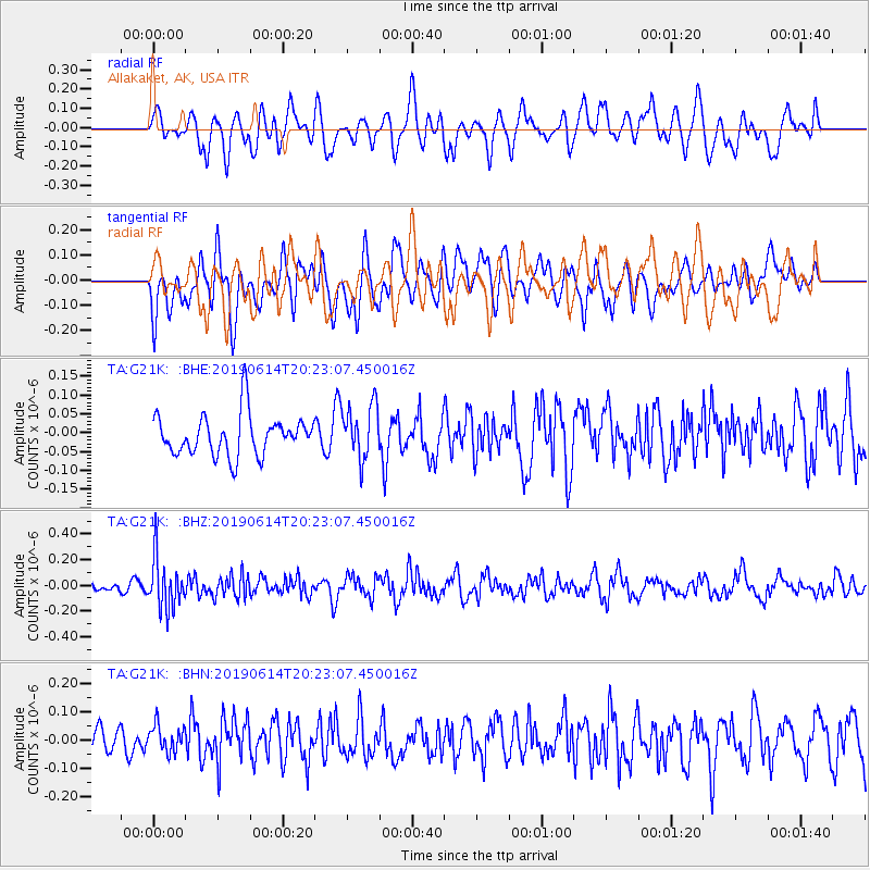
G21K Allakaket, AK, USA - Earthquake Result Viewer
*The percent match for this event was below the threshold and hence no stack was calculated.
| Earthquake location: |
Banda Sea |
| Earthquake latitude/longitude: |
-5.9/130.7 |
| Earthquake time(UTC): |
2019/06/14 (165) 20:10:52 GMT |
| Earthquake Depth: |
104 km |
| Earthquake Magnitude: |
5.6 Mww |
| Earthquake Catalog/Contributor: |
NEIC PDE/us |
|
| Network: |
TA USArray Transportable Network (new EarthScope stations) |
| Station: |
G21K Allakaket, AK, USA |
| Lat/Lon: |
66.52 N/153.51 W |
| Elevation: |
446 m |
|
| Distance: |
89.7 deg |
| Az: |
22.859 deg |
| Baz: |
254.656 deg |
| Ray Param: |
$rayparam |
*The percent match for this event was below the threshold and hence was not used in the summary stack. |
|
| Radial Match: |
59.36773 % |
| Radial Bump: |
400 |
| Transverse Match: |
53.82765 % |
| Transverse Bump: |
400 |
| SOD ConfigId: |
18369291 |
| Insert Time: |
2019-06-28 20:14:07.541 +0000 |
| GWidth: |
2.5 |
| Max Bumps: |
400 |
| Tol: |
0.001 |
|
Signal To Noise
| Channel | StoN | STA | LTA |
| TA:G21K: :BHZ:20190614T20:23:07.450016Z | 5.769184 | 1.9801271E-7 | 3.432248E-8 |
| TA:G21K: :BHN:20190614T20:23:07.450016Z | 0.8431757 | 4.6570648E-8 | 5.5232437E-8 |
| TA:G21K: :BHE:20190614T20:23:07.450016Z | 1.3196421 | 7.162094E-8 | 5.4273006E-8 |
| Arrivals |
| Ps | |
| PpPs | |
| PsPs/PpSs | |


