You are here: Home > Network List > AG - Arkansas Seismic Network Stations List
> Station HHAR Hobbs,AR > Earthquake Result Viewer
HHAR Hobbs,AR - Earthquake Result Viewer
| Earthquake location: |
San Juan Province, Argentina |
| Earthquake latitude/longitude: |
-31.6/-68.8 |
| Earthquake time(UTC): |
2016/11/20 (325) 20:57:43 GMT |
| Earthquake Depth: |
116 km |
| Earthquake Magnitude: |
6.4 MWP, 6.5 MWB |
| Earthquake Catalog/Contributor: |
NEIC PDE/NEIC COMCAT |
|
| Network: |
AG Arkansas Seismic Network |
| Station: |
HHAR Hobbs,AR |
| Lat/Lon: |
36.28 N/93.94 W |
| Elevation: |
421 m |
|
| Distance: |
71.6 deg |
| Az: |
338.759 deg |
| Baz: |
157.516 deg |
| Ray Param: |
0.053943746 |
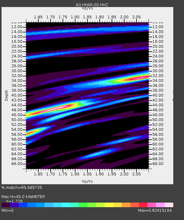
| Estimated Moho Depth: |
45.0 km |
| Estimated Crust Vp/Vs: |
1.73 |
| Assumed Crust Vp: |
6.53 km/s |
| Estimated Crust Vs: |
3.786 km/s |
| Estimated Crust Poisson's Ratio: |
0.25 |
|
| Radial Match: |
95.565735 % |
| Radial Bump: |
294 |
| Transverse Match: |
67.053566 % |
| Transverse Bump: |
400 |
| SOD ConfigId: |
1858631 |
| Insert Time: |
2016-12-04 20:57:52.112 +0000 |
| GWidth: |
2.5 |
| Max Bumps: |
400 |
| Tol: |
0.001 |
|

Signal To Noise
| Channel | StoN | STA | LTA |
| AG:HHAR:00:HHZ:20161120T21:08:21.699971Z | 24.522104 | 5.717728E-6 | 2.3316629E-7 |
| AG:HHAR:00:HHN:20161120T21:08:21.699971Z | 12.424141 | 1.8267789E-6 | 1.4703463E-7 |
| AG:HHAR:00:HHE:20161120T21:08:21.699971Z | 7.071502 | 1.2282475E-6 | 1.7368974E-7 |
| Arrivals |
| Ps | 5.2 SECOND |
| PpPs | 18 SECOND |
| PsPs/PpSs | 23 SECOND |


