You are here: Home > Network List > AG - Arkansas Seismic Network Stations List
> Station X40A Basin Creek Farm, Marlvern, AR > Earthquake Result Viewer
X40A Basin Creek Farm, Marlvern, AR - Earthquake Result Viewer
| Earthquake location: |
San Juan Province, Argentina |
| Earthquake latitude/longitude: |
-31.6/-68.8 |
| Earthquake time(UTC): |
2016/11/20 (325) 20:57:43 GMT |
| Earthquake Depth: |
116 km |
| Earthquake Magnitude: |
6.4 MWP, 6.5 MWB |
| Earthquake Catalog/Contributor: |
NEIC PDE/NEIC COMCAT |
|
| Network: |
AG Arkansas Seismic Network |
| Station: |
X40A Basin Creek Farm, Marlvern, AR |
| Lat/Lon: |
34.49 N/92.83 W |
| Elevation: |
158 m |
|
| Distance: |
69.6 deg |
| Az: |
338.931 deg |
| Baz: |
158.211 deg |
| Ray Param: |
0.055255324 |
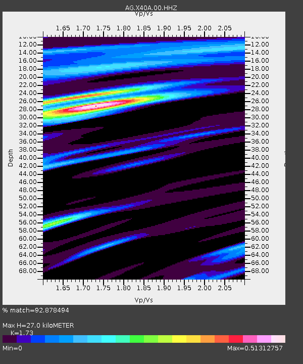
| Estimated Moho Depth: |
27.0 km |
| Estimated Crust Vp/Vs: |
1.73 |
| Assumed Crust Vp: |
6.498 km/s |
| Estimated Crust Vs: |
3.756 km/s |
| Estimated Crust Poisson's Ratio: |
0.25 |
|
| Radial Match: |
92.878494 % |
| Radial Bump: |
400 |
| Transverse Match: |
93.61876 % |
| Transverse Bump: |
400 |
| SOD ConfigId: |
1858631 |
| Insert Time: |
2016-12-04 20:57:59.685 +0000 |
| GWidth: |
2.5 |
| Max Bumps: |
400 |
| Tol: |
0.001 |
|
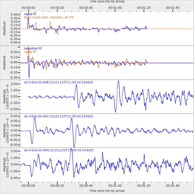
Signal To Noise
| Channel | StoN | STA | LTA |
| AG:X40A:00:HHZ:20161120T21:08:09.59499Z | 23.281239 | 4.7644053E-6 | 2.046457E-7 |
| AG:X40A:00:HHN:20161120T21:08:09.59499Z | 6.7302456 | 7.926345E-7 | 1.1777201E-7 |
| AG:X40A:00:HHE:20161120T21:08:09.59499Z | 8.235194 | 9.0188746E-7 | 1.09516236E-7 |
| Arrivals |
| Ps | 3.2 SECOND |
| PpPs | 11 SECOND |
| PsPs/PpSs | 14 SECOND |


