You are here: Home > Network List > CM - Red Sismologica Nacional de Columbia Stations List
> Station URI Uribia, Guajira, Columbia > Earthquake Result Viewer
URI Uribia, Guajira, Columbia - Earthquake Result Viewer
| Earthquake location: |
San Juan Province, Argentina |
| Earthquake latitude/longitude: |
-31.6/-68.8 |
| Earthquake time(UTC): |
2016/11/20 (325) 20:57:43 GMT |
| Earthquake Depth: |
116 km |
| Earthquake Magnitude: |
6.4 MWP, 6.5 MWB |
| Earthquake Catalog/Contributor: |
NEIC PDE/NEIC COMCAT |
|
| Network: |
CM Red Sismologica Nacional de Columbia |
| Station: |
URI Uribia, Guajira, Columbia |
| Lat/Lon: |
11.70 N/71.99 W |
| Elevation: |
68 m |
|
| Distance: |
43.2 deg |
| Az: |
355.383 deg |
| Baz: |
175.98 deg |
| Ray Param: |
0.07228066 |
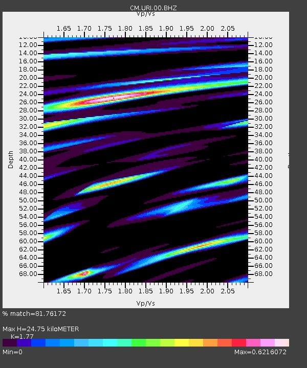
| Estimated Moho Depth: |
24.75 km |
| Estimated Crust Vp/Vs: |
1.77 |
| Assumed Crust Vp: |
5.738 km/s |
| Estimated Crust Vs: |
3.242 km/s |
| Estimated Crust Poisson's Ratio: |
0.27 |
|
| Radial Match: |
81.76172 % |
| Radial Bump: |
400 |
| Transverse Match: |
71.74181 % |
| Transverse Bump: |
400 |
| SOD ConfigId: |
1858631 |
| Insert Time: |
2016-12-04 20:58:36.215 +0000 |
| GWidth: |
2.5 |
| Max Bumps: |
400 |
| Tol: |
0.001 |
|

Signal To Noise
| Channel | StoN | STA | LTA |
| CM:URI:00:BHZ:20161120T21:05:03.068989Z | 12.021388 | 1.8182953E-6 | 1.5125502E-7 |
| CM:URI:00:BHN:20161120T21:05:03.068989Z | 6.158838 | 1.0967138E-6 | 1.7807156E-7 |
| CM:URI:00:BHE:20161120T21:05:03.068989Z | 1.5688887 | 2.7811916E-7 | 1.7727146E-7 |
| Arrivals |
| Ps | 3.5 SECOND |
| PpPs | 11 SECOND |
| PsPs/PpSs | 15 SECOND |


