You are here: Home > Network List > AV - Alaska Volcano Observatory Stations List
> Station MAPS Pakushin Southeast, Makushin Volcano, Alaska > Earthquake Result Viewer
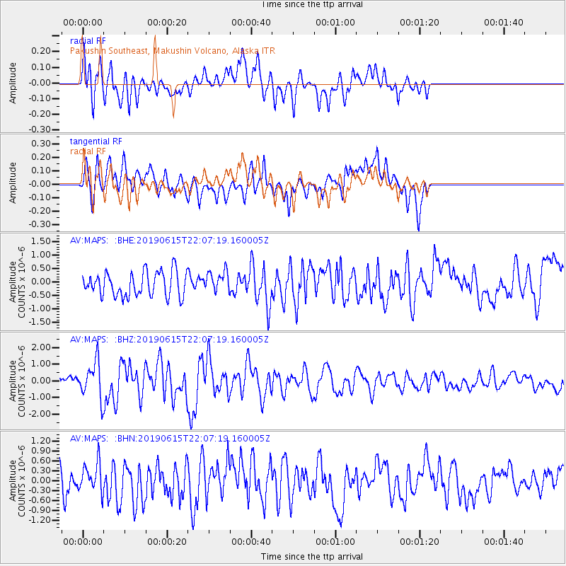
MAPS Pakushin Southeast, Makushin Volcano, Alaska - Earthquake Result Viewer
*The percent match for this event was below the threshold and hence no stack was calculated.
| Earthquake location: |
Tonga Islands |
| Earthquake latitude/longitude: |
-21.1/-174.0 |
| Earthquake time(UTC): |
2019/06/15 (166) 21:56:09 GMT |
| Earthquake Depth: |
10 km |
| Earthquake Magnitude: |
6.1 Mww |
| Earthquake Catalog/Contributor: |
NEIC PDE/us |
|
| Network: |
AV Alaska Volcano Observatory |
| Station: |
MAPS Pakushin Southeast, Makushin Volcano, Alaska |
| Lat/Lon: |
53.81 N/166.94 W |
| Elevation: |
333 m |
|
| Distance: |
74.9 deg |
| Az: |
4.349 deg |
| Baz: |
186.856 deg |
| Ray Param: |
$rayparam |
*The percent match for this event was below the threshold and hence was not used in the summary stack. |
|
| Radial Match: |
64.25526 % |
| Radial Bump: |
400 |
| Transverse Match: |
63.462986 % |
| Transverse Bump: |
400 |
| SOD ConfigId: |
18369291 |
| Insert Time: |
2019-06-29 21:58:01.000 +0000 |
| GWidth: |
2.5 |
| Max Bumps: |
400 |
| Tol: |
0.001 |
|
Signal To Noise
| Channel | StoN | STA | LTA |
| AV:MAPS: :BHZ:20190615T22:07:19.160005Z | 3.749746 | 1.1110714E-6 | 2.9630576E-7 |
| AV:MAPS: :BHN:20190615T22:07:19.160005Z | 1.3238249 | 4.3385458E-7 | 3.277281E-7 |
| AV:MAPS: :BHE:20190615T22:07:19.160005Z | 0.8785437 | 3.9075346E-7 | 4.4477412E-7 |
| Arrivals |
| Ps | |
| PpPs | |
| PsPs/PpSs | |


