You are here: Home > Network List > CN - Canadian National Seismograph Network Stations List
> Station UBRB Upper Baezaeko River, BC, CA > Earthquake Result Viewer
UBRB Upper Baezaeko River, BC, CA - Earthquake Result Viewer
| Earthquake location: |
Tonga Islands |
| Earthquake latitude/longitude: |
-21.1/-174.0 |
| Earthquake time(UTC): |
2019/06/15 (166) 21:56:09 GMT |
| Earthquake Depth: |
10 km |
| Earthquake Magnitude: |
6.1 Mww |
| Earthquake Catalog/Contributor: |
NEIC PDE/us |
|
| Network: |
CN Canadian National Seismograph Network |
| Station: |
UBRB Upper Baezaeko River, BC, CA |
| Lat/Lon: |
52.89 N/124.08 W |
| Elevation: |
1241 m |
|
| Distance: |
85.5 deg |
| Az: |
27.726 deg |
| Baz: |
225.79 deg |
| Ray Param: |
0.044729244 |
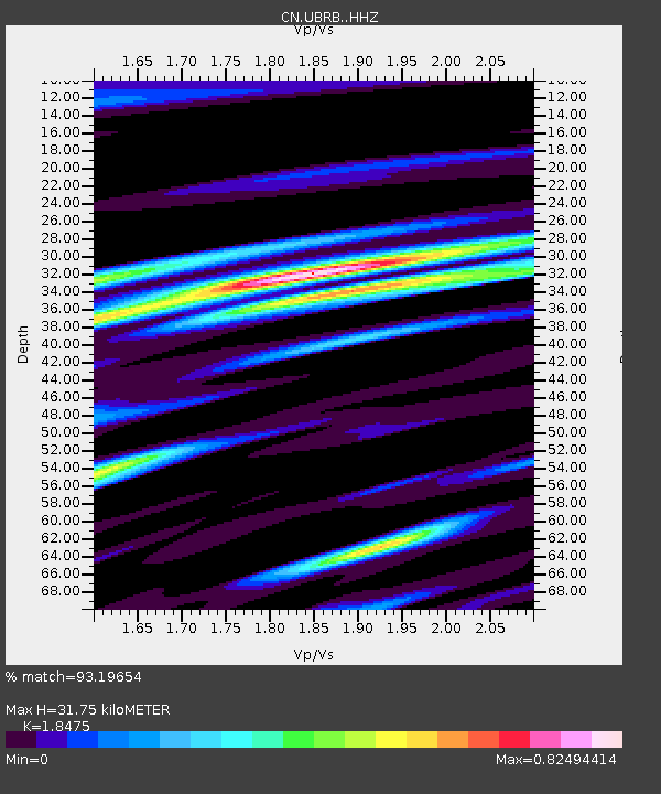
| Estimated Moho Depth: |
31.75 km |
| Estimated Crust Vp/Vs: |
1.85 |
| Assumed Crust Vp: |
6.566 km/s |
| Estimated Crust Vs: |
3.554 km/s |
| Estimated Crust Poisson's Ratio: |
0.29 |
|
| Radial Match: |
93.19654 % |
| Radial Bump: |
400 |
| Transverse Match: |
86.068825 % |
| Transverse Bump: |
400 |
| SOD ConfigId: |
18369291 |
| Insert Time: |
2019-06-29 21:59:37.220 +0000 |
| GWidth: |
2.5 |
| Max Bumps: |
400 |
| Tol: |
0.001 |
|

Signal To Noise
| Channel | StoN | STA | LTA |
| CN:UBRB: :HHZ:20190615T22:08:16.069978Z | 1.512467 | 1.617488E-7 | 1.0694369E-7 |
| CN:UBRB: :HHN:20190615T22:08:16.069978Z | 0.8530368 | 7.08428E-8 | 8.3047766E-8 |
| CN:UBRB: :HHE:20190615T22:08:16.069978Z | 0.8509306 | 7.167162E-8 | 8.422734E-8 |
| Arrivals |
| Ps | 4.2 SECOND |
| PpPs | 13 SECOND |
| PsPs/PpSs | 18 SECOND |


