You are here: Home > Network List > TA - USArray Transportable Network (new EarthScope stations) Stations List
> Station B18K Kokolik River, AK, USA > Earthquake Result Viewer
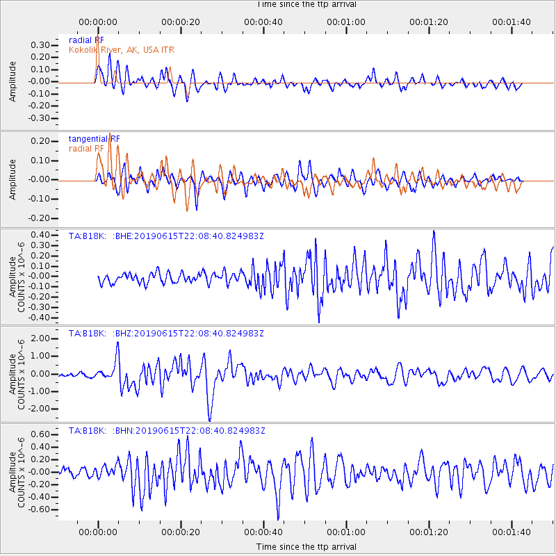
B18K Kokolik River, AK, USA - Earthquake Result Viewer
*The percent match for this event was below the threshold and hence no stack was calculated.
| Earthquake location: |
Tonga Islands |
| Earthquake latitude/longitude: |
-21.1/-174.0 |
| Earthquake time(UTC): |
2019/06/15 (166) 21:56:09 GMT |
| Earthquake Depth: |
10 km |
| Earthquake Magnitude: |
6.1 Mww |
| Earthquake Catalog/Contributor: |
NEIC PDE/us |
|
| Network: |
TA USArray Transportable Network (new EarthScope stations) |
| Station: |
B18K Kokolik River, AK, USA |
| Lat/Lon: |
69.36 N/161.80 W |
| Elevation: |
222 m |
|
| Distance: |
90.7 deg |
| Az: |
4.307 deg |
| Baz: |
191.406 deg |
| Ray Param: |
$rayparam |
*The percent match for this event was below the threshold and hence was not used in the summary stack. |
|
| Radial Match: |
86.59337 % |
| Radial Bump: |
400 |
| Transverse Match: |
84.377045 % |
| Transverse Bump: |
400 |
| SOD ConfigId: |
18369291 |
| Insert Time: |
2019-06-29 22:02:08.723 +0000 |
| GWidth: |
2.5 |
| Max Bumps: |
400 |
| Tol: |
0.001 |
|
Signal To Noise
| Channel | StoN | STA | LTA |
| TA:B18K: :BHZ:20190615T22:08:40.824983Z | 9.855992 | 5.8413895E-7 | 5.9267393E-8 |
| TA:B18K: :BHN:20190615T22:08:40.824983Z | 1.8650388 | 9.980185E-8 | 5.3511947E-8 |
| TA:B18K: :BHE:20190615T22:08:40.824983Z | 1.1668406 | 5.2049813E-8 | 4.4607475E-8 |
| Arrivals |
| Ps | |
| PpPs | |
| PsPs/PpSs | |


